Merchandise sales locations will be closed state-wide for the required annual inventory beginning Wednesday, April 15 and will reopen when completed on April 16.
Open fires are prohibited throughout the park from midnight to 4 p.m., Feb. 15 through April 30. Learn more.
Sweet Run State Park
11661 Harpers Ferry Road, Hillsboro, VA 20132; Phone: 540-668-6230; Email: sweetrun@dcr.virginia.gov
Latitude, 39.292493755334. Longitude, -77.72578783966.


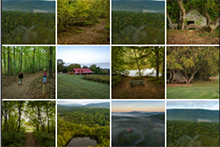
Photos and video

The park is open from 8 a.m. to dusk. Parking is limited.
The office is located at the Demory-Wortman House and is open by appointment only. Please email sweetrun@dcr.virginia.gov to schedule an appointment.
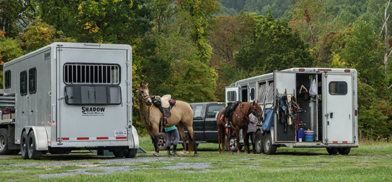
Eleven miles of trails are open to the public. Equestrian parking is located at the Sawmill Access, only.
The park is currently in developmental status and there are currently no overnight facilities available.
Please review the Virginia State Parks Know Before You Go information before you visit.
General Information
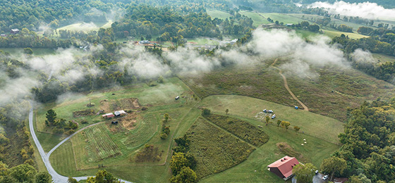
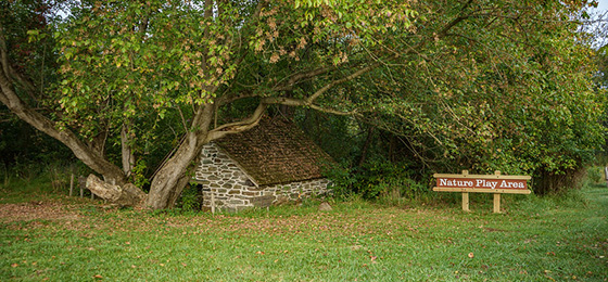
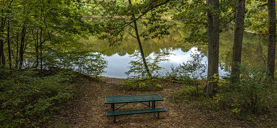
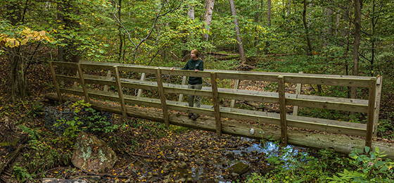
The park is currently under development. It features expansive views of the Blue Ridge Mountains. Sweet Run and Piney Run streams bisect the property. The property includes eleven miles of hiking and nine miles of equestrian trails along streams, through mature forest, meadows and mountain-side terrain, and has a picnic pavilion and nature play area for children. Parking is limited. The property is steeped in history, featuring the ruins of a 19th century farming community. It also has a restored farmhouse built in the 1840s.
Hours
8 a.m. to dusk.
Location
Sweet Run State Park is located in Loudoun County, approximately four miles from Harpers Ferry, WV. From Route 7 west of Leesburg, take Route 9W (Charles Town Pike); after 10 miles, bear right onto Harpers Ferry Road (SR-671). Travel 5.6 miles and turn left into the park.
From US-340, turn onto Harpers Ferry Road (SR-671) and travel two miles, then turn right into the park.
The park address is 11661 Harpers Ferry Road, Hillsboro, VA 20132; Latitude 39.293534, Longitude -77.721184
Drive time: Northern Virginia, up to one and a half hours (the park is in Northern Virginia); D.C., over one hour; Richmond, two and a half hours; Tidewater/Norfolk/Virginia Beach, four hours; Roanoke, three and a half hours
Park Size
884 acres.
Follow us

Cabins, camping
OVERNIGHT FACILITIES
Sweet Run currently has no camping available. Hike-in, primitive campground is currently under development.
Recreation
TRAILS
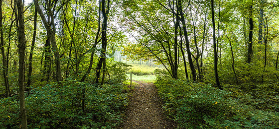
The property includes eleven miles of hiking and nine miles of equestrian trails along streams, through mature forest, meadows, and mountain-side terrain. Trails can be accessed from the park’s main entrance, as well as at the ends of Arnold Lane and Sawmill Lane. Equestrian parking is available in the Sawmill Access parking area only. Note: Creek crossings without bridges are required on Butterfly Alley, Bypass, Lower Sweet Run and Piney Run Trails
SWIMMING
None at this park.
BIKING
There are currently no bike-accessible trails in the park.
FISHING, BOATING
The park offers hike-in fishing at Gordon Pond. Fishing requires an approximate 1-mile hike from the nearest parking area at the end of Arnold Lane. Parking is limited. All Virginia freshwater fishing regulations apply. A valid Virginia State fishing license, which can be purchased online or through local retailers, is required for those 16 and older. Fish species in the pond include sunfish, largemouth bass, and crappie. Wading and the use of flotation devices are prohibited. Caution should be used along the shoreline in the vicinity of the dam where sudden drop offs exist.
HORSES
There are no horse rentals available, but the park has nine miles of bridle trails for horses. State law requires riders to carry a copy of a negative Coggins report for each horse brought to the park. All horse trailer parking is at the Sawmill Access parking area. Caution should be used when driving on Sawmill Lane which is narrow and contains sharp curves.
Park Trail Guide
Click here for the park's trail guide.
Download (external link for use with Avenza App) the geo-referenced map
Download the geo-referenced map for this park
Nearby Attractions
Continue to combine hiking, nature and history at Harpers Ferry National Historical Park, C&O Canal National Historical Park, or along the Appalachian Trail or Potomac Heritage National Scenic Trail. You can also visit Loudoun County’s Banshee Reeks Nature Preserve.
Adventure awaits with rafting, tubing, and more, offered by nearby outfitters including Harpers Ferry Adventure Center, River & Trail Outfitters, and River Riders.
Wineries and breweries abound in Loudoun County – nearby choices include Breaux Vineyards, Kalero Vineyard, 868 Estate Vineyards and Harpers Ferry Brewing. Farm stands, markets, and pick-your-own establishments offer seasonal treats year round. The nearby town of Hillsboro holds a variety of events and festivals throughout the year, often with food trucks and locally produced wine offered for ready-made picnicking.
Picnic Shelters
The park has one trail shelter located on the Farmstead Loop Trail. The shelter is a quarter-mile hike from the nearest parking lot at the park’s main entrance.
Meeting Space and Facilities
MEETING FACILITIES
None.
VISITOR CENTER, GIFT SHOP
None.
RESTAURANT
None.
LAUNDRY
None.
ENVIRONMENTAL EDUCATION CENTER
None.
Other Info
ACCESSIBILITY
The trails are not ADA accessible. Wheelchair accessible restrooms are located in the Interpretive Center.
NATURE, HISTORY PROGRAMS
The park will conduct ranger-led and partner-based interpretive programs that highlight the park's natural and cultural history. Programs will be offered year-round.
CONCESSIONS
None.
HISTORY
In 1999, the Robert and Dee Leggett Foundation purchased nearly 900 acres of woodlands and farmland on the eastern slope of the Blue Ridge Mountain. The property was named the Blue Ridge for Environmental Stewardship and a non-profit was formed to manage the land for the Foundation. Jointly, they conserved and stewarded the property’s natural and cultural resources, encouraged public access and recreation, provided environmental education opportunities and supported organic-like agriculture. Between 2018 and 2022, the Foundation donated the property to Virginia State Parks. In 2022, funding was appropriated to begin its transformation into Sweet Run State Park. Visitors to the park will experience the rich natural and cultural history of the “Between the Hills” valley of northern Loudoun County. This valley lies between the Blue Ridge and Short Hills Mountain. Every turn of a trail reveals historic structures, stone walls, road beds, earthen dams and many more remains of a once-robust backwoods settlement.
Beginning in the late 1700s, a collection of settlers comprised what became known as the “Waters” community centered around the confluence of Piney and Sweet Runs. These settlers farmed the land for subsistence until more significant roadways, canals and railroads along the nearby Potomac River provided opportunities for the production, transport, and sale of cash crops such as wheat and corn. In addition to farming, local residents forested the Blue Ridge for lumber and charcoal. This was to supply the forges and factories comprising the federal armory in nearby Harpers Ferry, Virginia (now West Virginia). To this day, visitors to the park can find the charcoal hearths, road networks and other structures of the Waters community.
Sweet Run’s American Civil War story represents life in a border region where views on union vs. secession and enslavement vs. freedom radically differed. Between the Hills residents witnessed frequent movement and occupation of Union and Confederate troops. They also witnessed battles in and around Harpers Ferry, and clashes between Union cavalry and Confederate partisans led by Colonel John S. Mosby. During the war, a new border formed along the crest of the Blue Ridge when West Virginia became the 35th state in the Union in June 1863.
Following the Civil War and into the early 1900s, with the introduction of mechanization and large-scale agriculture, farms were consolidated, and the rural population of Loudoun County, including those in the Waters community, declined. Those who remained profited by shifting to dairy production, livestock and poultry operations destined to supply local cities. However, competition from Big Agriculture gradually squeezed out small farmers.
From the 1950s to the 1990s, as the countryside emptied, prospective developers acquired the collection of properties that now comprise the park. They had hopes of building a golf course community. It was at this time that three large ponds were created from Piney and Sweet Runs. These ponds are near today’s Legacy Loop and Piney Run Trails. Today, only Gordon Pond remains, the other two destroyed by Tropical Storm Agnes floods in 1972. This is just one of the many natural resources that the Leggett Foundation/Blue Ridge Center and now Sweet Run State Park preserve. It also preserves its unique local history for our visitors’ enjoyment.
FRIENDS GROUPS
Between the Hills Conservancy serves as a community support organization for Sweet Run State Park, and also conducts business as the Friends of Sweet Run. Their mission is to advocate for the conservation and stewardship of the natural, cultural, historical, and agricultural resources of Sweet Run State Park and the Between the Hills region. To learn more about the group, click here.
U.S. Trail Ride also supports Sweet Run State Park facilities and programs, with particular dedication to trail maintenance. To find more information about U.S. Trail Ride or to join, click here.
MASTER PLAN
A master plan must be written for a park before it is built. The plan is updated at least every ten years thereafter. The plan covers the size, types, infrastructure and locations of facilities, and the site's special features and resources. Three public meetings are held during the initial development of each plan. Sweet Run State Park is in the process of developing a master plan. Click here for this park's master plan details.
Events, Programs
- 04/11/2026 - Park Tales and Tails- From Survival to Stewardship
- 04/11/2026 - Contain your Garden!- Container Gardening Workshop
- 04/11/2026 - Sensing Spring: A Forest and Sound Experience
- 04/11/2026 - Earth and Sky Adventures
- 04/12/2026 - Park Tales and Tails- From Survival to Stewardship
- More events at this park.

Blogs
- Virginia birds in "The 12 Days of Christmas"
- See Virginia’s fall colors in a whole new way: Join a ranger-led adventure
- Seven September adventures
- Reel in the fun fishing at a Virginia State Park
- Colorful winter woods at Virginia State Parks
- More blogs about this park.
At a Glance


 Trail")


