Merchandise sales locations will be closed state-wide for the required annual inventory beginning Wednesday, April 15 and will reopen when completed on April 16.
Open fires are prohibited throughout the park from midnight to 4 p.m., Feb. 15 through April 30. Learn more.
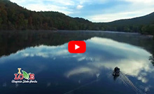
Hayfields State Park
524 Hayfields Lane, McDowell, VA 24458; Phone: 540-396-4489; Email: Hayfields@dcr.virginia.gov
Latitude, 38.26187. Longitude, -79.55292.


Photos and video


This content takes priority over any other information provided on this park's web page except for site alerts.
The park is open daily, 9 a.m.-7 p.m.
Please review the Virginia State Parks Know Before You Go information before you visit.
General Information
Hayfields State Park is located in Highland County between Bullpasture and Jack Mountains at an elevation ranging from 1,800 to 2,400 feet. It features a mix of heavily wooded mountain land, valley pastures and several structures, including an 1800s farmhouse. The Bullpasture River flows through the property for about a mile and is home to numerous threatened and endangered species.
The park features 4 miles of easy-to-moderate hiking and biking trails and fishing access along the Bullpasture River.
Hours
The park is open daily, 9 a.m.-7 p.m.
Location
Coming from Staunton/Churchville VA:
- Take Rte. 250 through Churchville. You will then cross Shenandoah Mountain, Shaw’s Ridge, and Bullpasture Mountain.
- Once over Bullpasture Mountain you will come to the village of McDowell.
- Take your first left passing the old elementary school (now owned by the Ruritan Club) on your left, and the McDowell Fire Department on your right. This is Bullpasture River Rd.
- Take Bullpasture River Rd. South for approximately 7 miles.
- Look for a sign on the left hand side of the road that says “Hayfields State Park”
- You will then take your next left (farm gate will be open) after the sign at 524 Hayfields Ln – there will be a long line of pine trees flanking the gravel road.
Coming from Lexington:
- Take I64 West
- Take Exit 43 towards Goshen (SR780)
- In Goshen, turn left onto Virginia Ave
- Turn Right onto Indian Draft Rd
- Stay right onto Indian Draft Rd; it will eventually become Bullpasture River Rd.
- You will then take a right at the park entrance (farm gate will be open) at 524 Hayfields Ln– there will be a long line of pine trees flanking the gravel road.
Coming from Covington:
- Stay on Rte. 220 north and go through Hot Springs and Warm Springs
- Take right onto Muddy Run Rd.
- Once in the village of Williamsville, take a left onto Dry Run Rd.
- Dry Run Rd becomes Burnsville Rd.
- Take a left onto Bullpasture River Rd.
- You will then take a right at the park entrance (farm gate will be open) at 524 Hayfields Ln– there will be a long line of pine trees flanking the gravel road.
Coming from Clifton Forge:
- Take I64 east to exit 29.
- Take Rte 42 North
- Take a left onto Mountain Valley Rd (look for a Citgo Gas Station on the right) and then a right onto Indian Draft Rd.
- Indian Draft Rd will turn into Bullpasture River Rd.
- You will then take a right at the park entrance (farm gate will be open) at 524 Hayfields Ln– there will be a long line of pine trees flanking the gravel road.
Coming from Monterey:
- Take Rte 250 east towards McDowell.
- In McDowell, take a right by McDowell Presbyterian Church onto Bullpasture River Rd.
- Follow Bullpasture River Rd for approximately 7 miles
- Just before park entrance, look for a sign that says “Hayfields State Park” on the left hand side of the road in a curve.
- You will take the immediate left after the sign. Look for a straight gravel road flanked by a long line of pine trees (this is 524 Hayfields Ln).
Park Size
1034 acres
Follow us

Cabins, camping
OVERNIGHT FACILITIES
There are no overnight facilities at this time.
Cabins
None.
Lodges
None.
Yurts
None.
Camping Cabin
None.
Bunkhouse
None.
Camping
None.
Recreation
TRAILS
The park currently hosts 4 miles of trails with more under development. Enjoy a peaceful, easy stroll along Riverside Trail (1 mile loop) or Bear Pond Trail (1-mile loop) or be challenged on Eagles Rest Trail which hosts an overlook with stunning views of the Bullpasture River and valley. Lastly, Laurel Loop trail (1-mile) will take you into the woods to see mountain laurel and other vibrant plants.
SWIMMING
There are no designated swimming areas at this time.
FISHING AND BOATING
The park hosts one mile of riverfrontage along the Bullpasture River, famous for its trout flyfishing access. A state freshwater fishing license and trout stamp are required.
HORSES
Not available at this time.
HUNTING
Not available at this time.
Park Trail Guide
Click here for the park's trail guide.
Download (external link for use with Avenza App) the geo-referenced map
Download the geo-referenced map for this park
Nearby Attractions
- Douthat State Park (Bath County)
- George Washington National Forest
- Highland Wildlife Management Area
- Town of McDowell – museum, gas, general store
- Town of Monterey – Museums, gas, restaurants, vendors, etc.
- McDowell Battlefield
- Hot Springs/Warm Springs (Bath County)
- The Homestead/Omni Hotel (Bath County)
Picnic Shelters
Not ListedMeeting Space and Facilities
MEETING, CONFERENCE, WEDDING FACILITIES
Hayfields State Park has a small meeting room available at the park office. Call the park office for more details.
VISITOR CENTER, GIFT SHOP
TBD
RESTAURANT
None at this time.
LAUNDRY
None at this time.
Other Info
HISTORY
The park office occupies a late 19th century farmhouse and on the western side of the park, there is a small cabin dating to the 1840s, where a local doctor practiced.
Events, Programs
- 04/22/2026 - Leave-No-Trace 101
- 05/02/2026 - Bullpasture River Clean-up
- 05/16/2026 - Snorkle the Bullpasture River
- 06/06/2026 - Eagle's Rest Hike
- 06/15/2026 - Eagle's Rest Hike
- More events at this park.

At a Glance


