
Read Our Blogs
Over the River and through the Tunnels We Go
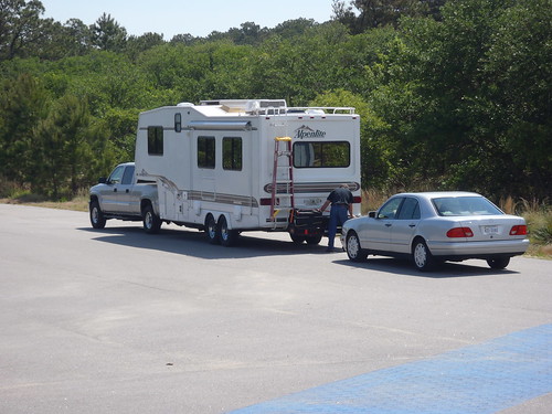
On your way to the Hampton Roads area for a visit? When traveling to the Hampton Roads area, traffic congestion and the confusing array of bridges and tunnels can be frustrating! Read these tips for a smoother ride!
Bordered by that Atlantic, on the shores of the Chesapeake Bay and beribboned with rivers, visiting coastal Virginia State Parks requires crossing over bridges and tunnels. In order to reach the state parks of Belle Isle, Chippokes, False Cape, First Landing and Kiptopeke from outside the Hampton Roads area one or more of the area's bridges and/or tunnels must be used.
Check tunnel and bridge height/weight restrictions and traffic conditions on your way to coastal Virginia state parks for a smoother ride!
To help keep traffic flowing, VDOT is now broadcasting traffic information on 1680AM. You can also get traffic information by cell phone by dialing 511 or visiting 511virginia.org. However, many people listen to the traffic reports on popular radio stations and the abbreviations used by these DJs can make your head spin. Click here for a detailed VDOT information page about height and weight restrictions and propane tank inspections on the bridges and tunnels in the Hampton Roads area.
Local news' stations do a great job posting traffic updates on their Facebook pages. Local channels WAVY, WVEC and WTKR are the call letters of the major networks. In addition, radio stations Movin' 107.7, 94.9 The Point, and 93.7 BOB FM do regular updates, as to most radio stations, during peak travel times.
Streaming traffic camera footage can be viewed on the Virginian-Pilot, the local newspapers, partner site HamptonRoads.com. This page also posts tweets from the 511 traffic system and has additional traffic updates.
I usually estimate 6 minutes of extra travel time for each miles of tunnel back-up. For instance, if the tunnel is backed up three miles, I add about 18 minutes to my travel time. Be sure to map our your main route and an alternative route before you head out to Virginia State Parks in the Hampton Roads area.
The following list of abbreviations and location information can help you navigate the area and get to your Virginia State Park destination on time and in a good mood! Sometimes, drivers are encouraged or required to take an alternate route due to accidents or congestion. Please print this blog post and put it with your reservation information!
CBBT = Chesapeake Bay Bridge-Tunnel is located on Highway 13 connecting Virginia Beach to the Eastern Shore Peninsula; going over and under the Chesapeake Bay) $12 one way toll; $17 round trip toll if completed in 24 hours. The Chesapeake Bay Bridge-Tunnel is a destination in and of itself with a gift shop, observation deck and fishing pier.
HRBT = Hampton Roads Bridge-Tunnel is located on I-64 between Norfolk and Hampton; going over and under the James River
MMBT = Monitor Merrimac Bridge-Tunnel is located on I-664 connection Hampton and Portsmouth; going over and under the James River
HRB = High Rise Bridge is located on I-64 at the southern end of Chesapeake; going over the Elizabeth River
JRB = James River Bridge is located on Route 17 connecting Hampton and Suffolk; going over the James River
Berkley Bridge and Downtown Tunnel is located on I-464 in downtown Norfolk; going over and under the Elizabeth River; construction is ongoing at this location through 2013 and 2014.
Gilmerton Bridge is located off I-464 and Military Highway; going over the Elizabeth River
South Norfolk Jordan Bridge is usually shorted to just "Jordan Bridge" connects Portsmouth with Chesapeake over the Elizabeth River. Newly rebult, there is a toll charge that varies at peak times to use this bridge
Midtown Tunnel is located on I-264 connecting Norfolk and Portsmouth; going over and under the Elizabeth River
Coleman Bridge is located on Route 17 connecting Newport News to the Northern Neck; going over the York River' $2 toll going north; no charge going south
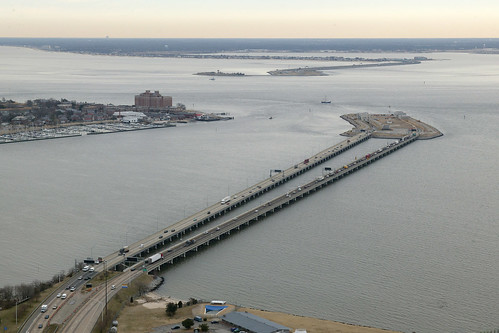
Aerial view of the Hampton Roads Bridge Tunnel (courtesy of VDOT Flickr page)
First Landing State Park is located in Virginia Beach. From I-64, take Northampton Blvd.-U.S. 13 North (Exit 282). Go through eight lights, then turn right at the Shore Drive/U.S. 60 exit (last exit before the Chesapeake Bay Bridge Tunnel). Take a right on Shore Drive and go four and a half miles to the park entrance. To reach the Chesapeake Bay Center, park office, camping or cabins, turn left off U.S. Rt. 60 at the stoplight and check in at the contact station. For the Trail Center, picnic area and trails, turn right instead.
Drive Time: Northern Virginia, three and a half hours; Richmond, two hours; Tidewater/Norfolk/Virginia Beach, 20-30 minutes (this facility is in the area); Roanoke, five and a half hours
False Cape State Park is located is Virginia Beach. LOCATION: From Interstate 64, exit on to Indian River Road East. Go 13 miles, then turn left onto Newbridge Road, then right onto Sandbridge Road. Next, turn right onto Sandpiper Road to Little Island City Park. Parking fees required Memorial Day to Labor Day. Day use only parking also is available at Back Bay Wildlife Refuge.
From First Landing State Park and oceanfront, turn east onto Shore Drive (Route 60); follow Pacific Avenue to General Booth Boulevard, then left on Princess Anne Road and then straight onto Sandbridge Road. Turn right onto Sandpiper Road to Little Island City Park. Parking fees are required from Memorial Day to Labor Day.
Drive Time : From Virginia Beach's oceanfront to Little Island city parking lot is about 40 minutes.
Note: Groups of 10 or more are required to obtain a special-use permit from Back Bay Wildlife Refuge two weeks in advance of trip.
The tram for False Cape operates from April 1 through October 31 on a first-come, first-served basis. Call the park at (757) 426-7128 for more information.
Chippokes State Park is located in Surry County. From I-95 and I-295, take Route 10 towards Hopewell. Follow Route 10 East for approximately 40 miles to Surry. Turn left at the intersection of routes 10 and 31 (this continues on Route 10). Turn right at the stop light. Turn left at Route 634 (Alliance Road), and the park entrance is four miles on the left.
Drive Time: Northern Virginia: 2 - 3 hours; Richmond: 1.5 hours; Tidewater/Norfolk/Virginia Beach: 1.5 hours; Roanoke: 4 hours
Kiptopeke State Park is located on the eastern shore of Virginia, this park offers recreational access to the Chesapeake Bay and the chance to explore a unique coastal habitat featuring a major flyway for migratory birds. Kiptopeke is three miles from the northern terminus of the Chesapeake Bay Bridge Tunnel, which has a substantial each-way toll charge, on Route 13. Turn west on Route 704; the park entrance is within a half mile. The park has an area for swimming Memorial Day to Labor Day.
Drive Time: (Bay Bridge Tunnel Traffic may extend time) Northern Virginia, four hours; Tidewater/Norfolk/Virginia Beach, 45 minutes; Richmond, two hours; Roanoke, five hours.
Belle Isle State Park is located in Lancaster County on the Rappahannock River. From Warsaw, take State Route 3 East to SR 354. Turn right and follow for three miles. Turn right onto SR 683 at Somers to the park entrance. From Kilmarnock, take Route 3 West to Lively, then left on SR 201 for three miles, then right on SR 354 for three miles and left onto 683 to the park entrance.
Drive Time: Northern Virginia: two hours; Richmond: two hours; Tidewater/Norfolk/Virginia Beach: two hours; Roanoke: five hours


If you have read the article and have a question, please email nancy.heltman@dcr.virginia.gov.
Search for blogs
By Park
Categories
Cabins
Camping
Fishing
History and Culture
Other
Programs and Events
Trails
Volunteers
Water Fun
Archive
2025
2024
2023
2022
2021
2020
2019
2018
2017
2016
2015
2014
2012


