Open fires are prohibited throughout the park from midnight to 4 p.m., Feb. 15 through April 30. Learn more.

Read Our Blogs
Bridging Space and Time
Shared by Kayla Lehman, as Guest Blogger.
by Kayla Lehman; reprinted with permission. Kayla wrote this for her 10th grade English class. The assignment required that she use Mark Twain’s style to write a paragraph about a place that had meaning to her.
At High Bridge Trail State Park, a wooden bridge stretches out across the broad valley, straddling two hills that plunge to meet one another at the bottom of a deep abyss. I wander among a stream of tourists, until I stop to lean over the tall wooden walls and gaze out at the valley beyond. Out there is a world so different from the one we know, untouched by man, save the monumental work of architecture beneath my feet. The great bridge has touched people’s lives for centuries, still standing now as a relic of a bygone era.
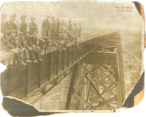
Photo of High Bridge from 1914
Trains once travelled swiftly across its length, and in still another time it served noble soldiers until it was reduced to cinders by a great fire that consumed its wooden framework, but, like a phoenix from its ashes, it was reborn into new purpose, traversed now by man rather than machine.
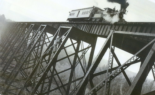
High Bridge in 1963
The bridge connects more than one side of the valley to the other; it is a bridge between past and present, between man and nature. ~Kayla Lehman
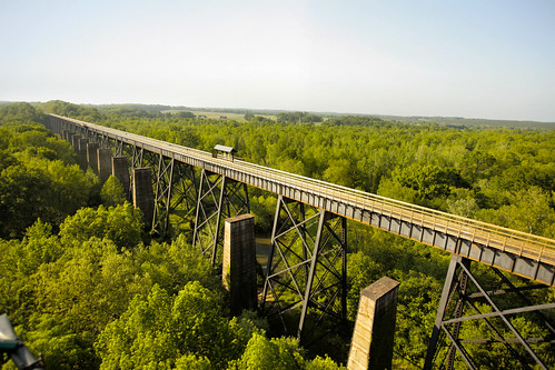 High Bridge Trail State Park today is enjoyed by hikers, bikers and horseback riders
Today, hikers, bikers, and horseback riders enjoy High Bridge Trail. Once a rail bed, the trail is wide, level and generally flat. Its surface is finely crushed limestone, making it easy for everyone to enjoy. Its centerpiece, the majestic High Bridge, is more than 2,400 feet long and 125 feet above the Appomattox River. It is the longest recreational bridge in Virginia and among the longest in the United States.
Bring plenty of drinking water because it's not available on the trail. There are various access points along the trail including municipal parking lots in Farmville, others are at River Road in Cumberland County; Osborne Road in Farmville; Heights School Road in Prince Edward County; and at Rice, Tuggle and Prospect. Horse trailer parking is available at Prospect, Osborne Road and Heights School Road.
Trip suggestions:
The parking lot closest to High Bridge is at River Road. Consider these tips:
- For pedestrians and hikers, the bridge is nearly a mile away.
- Trailers are not allowed at the River Road parking lot.
- Bikers might prefer parking at the Rice parking lot, which is 3.1 miles from the bridge and 8 miles from Farmville. Bikers might also wish to park at the Main Street plaza parking lot in Farmville; the bridge is 4.5 miles from that lot.
- For equestrians, the designated horse trailer parking lots are at Osborne Road, which is about 2.9 miles from the bridge, and at Prospect, which is 12.4 miles to High Bridge.
View Larger Map


If you have read the article and have a question, please email nancy.heltman@dcr.virginia.gov.
Search for blogs
By Park
Categories
Cabins
Camping
Fishing
History and Culture
Other
Programs and Events
Trails
Volunteers
Water Fun
Archive
2026
2025
2024
2023
2022
2021
2020
2019
2018
2017
2016
2015
2014
2012


