Open fires are prohibited throughout the park from midnight to 4 p.m., Feb. 15 through April 30. Learn more.
Sky Meadows State Park
11012 Edmonds Ln., Delaplane, VA 20144; Phone: 540-592-3556; Email: SkyMeadows@dcr.virginia.gov
Latitude, 38.988703. Longitude, -77.968913.


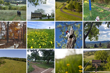
Photos and video


This content takes priority over any other information provided on this park's webpage.
The park is open daily from 8 a.m. to dusk.
The Visitor Center/Gift Shop is open daily, 10 a.m.-4 p.m. The Visitor Center/Gift Shop is also open on select evenings when the park holds astronomy programs. The park office is open Monday-Friday, 9 a.m.-4 p.m.
The Children's Discovery Area is open.
The Sensory Trail is open.
The park is designated as an International Dark Sky Park and holds monthly astronomy programs. Check the program and event listings for the schedule.
For self-guided observation, the park has designated Turner Pond as its official Dark Sky Observation Area. Here, astronomers and stargazers may practice astronomy after ordinary park hours. See details in our Other Info section.
Overnight facilities are open for reservations. Backcountry camping is open.
Please review the Virginia State Parks Know Before You Go information before you visit.
General Information
Rich in history, this park provides recreational offerings that engage visitors and help connect them with farming practices that formed its unique pastoral landscape. This 1,860-acre park has scenic views, woodlands and the rolling pastures of a historic farm that captures the colonial through modern life of the Crooked Run Valley. Nature and history programs are offered year-round. Hiking, picnicking, fishing and primitive hike-in camping for families and groups are favorite activities in this peaceful getaway on the eastern side of the Blue Ridge Mountains. The park has 10.5 miles of bridle trails, 22 miles of hiking trails, 9 miles of bike trails and Appalachian Trail access.
Hours
8 a.m. - dusk.
Location
The park is less than two miles south of Paris, Va., via U.S. Route 50 to Route 17 South; or seven miles north of I-66, Exit 23 on Route 17 North. The park's main entrance is on State Route 710.
Its address is 11012 Edmonds Lane, Delaplane, VA 20144-0710.
Latitude, 38.988703. Longitude, -77.968913.
Drive Time: Northern Virginia, 45 minutes to one hour; D.C., over one hour; Richmond, two hours; Tidewater/ Norfolk/ Virginia Beach, three hours; Roanoke, two and a half hours
Park Size
1,860 acres.
Follow us

Cabins, camping
OVERNIGHT FACILITIES
Enjoy a unique and peaceful camping experience at Sky Meadows. The park offers year-round primitive hike-in tent camping nestled against the base of the Blue Ridge Mountains. Campers must hike Hadow Trail 1 mile with their gear from the overnight parking area to get to these campsites. The campground is accessible by bike, but no vehicles are allowed near campsites. Reservations are required for group campsites and recommended for individual sites. Camping equipment must be placed within the perimeter of the designated campsite.
See a detailed map of the campsites.
Appalachian Trail hikers arriving without a reservation and camping overnight within park boundaries MUST camp in the designated primitive camping area, Site AT, located 1-1/4 miles from the Appalachian Trail. Camping fees apply. Self-pay at the Firewood honor system boxes or at the Visitor Center for the AT site.
The park has no cabins or drive-to campsites.
For general information about Virginia State Parks accommodations, amenities or to make a reservation, you can reserve online or call 1-800-933-PARK. Click here for park fees.
Those interested in other parks' overnight accommodations, rental rates for cabins and camping should know that offerings vary by season and park. Rates are subject to verification by DCR's state parks reservations staff (1-800-933-PARK). First, determine the park, the season (which varies by park), then the rate. Click here for park system fees.
Camping
All primitive
Reservations
- Camping guests must set up on a campsite with the color and number matching what they reserved. Fifteen individual primitive tent sites have red signs numbered 1 through 15; the Buddy Sites have a blue signs; Camp Slater has a brown sign; Camp Washington has a green sign.
- Walk-in honor camping is available for only one night at a time and only for red (individual sites).
Accommodations
- Pit toilets, non-potable water, bear-proof trash cans and firewood are available in the campground.
- Firewood brought from outside the park is prohibited. Campers may use dead, fallen wood around the campsites or buy firewood at the campground. The cost is $6 per 10 sticks of firewood. Campers may not cut trees, brush or saplings.
- Each campsite has a 16' x 16' tent pad, picnic table, bear-proof locker, lantern hook and fire pit with a small grate. Individual (red) campsites 2, 3, 4, 5, 6, 8, 9, 13 and 15 are equipped with hammock posts. Buddy Site #2 also has hammock posts.
Campers must keep all equipment on the site's camping pad. Check-in, 4 p.m.; checkout, 1 p.m.
Site types
- RD Red (Individual) - 15 primitive hike-in tent sites are marked by red signs in the campground. Reservations are site-specific for individual red sites. Individual sites accommodate up to six people. Fees include parking for two vehicles.
- BUD Blue (Buddy) – These sites are ideal for two families wishing to camp together. Each is marked by a blue sign. These sites are unsuitable for groups. They have two tent pads, a bear-proof locker, and a shared picnic and grill pad. Buddy Site #2 is equipped with hammock posts. Each Buddy site accommodates up to 12 and must be reserved ahead of time. Fees include parking for four vehicles.
- SLAT Brown (Camp Slater) - This is a small primitive tent group camp area that accommodates up to 24 people. It is marked by a brown sign and has four tent pads, a bear-proof locker, and a shared picnic and grill area. It must be reserved ahead of time. Fees include parking for six vehicles.
- WASH Green (Camp Washington): This is a large primitive tent camping area for groups of up to 36 people. It’s marked by a green sign and has six tent pads, a bear-proof locker, and a shared picnic and grill area. It must be reserved ahead of time. Fees include parking for eight vehicles.
Total sites: 19
Recreation
TRAILS
The park has 22 miles of hiking trails, 10.5 miles of bridle trails and 9 miles of biking trails ranging from easy to difficult. The park also accesses the Appalachian Trail with 3 miles of the trail running through the park. Overnight parking is available for AT hikers (up to 14 days). Overnight AT hikers should register at the visitor center during open hours or at the overnight parking kiosk near the park's main entrance after hours. The park is a three-day hike from Harpers Ferry and a two-day hike from Shenandoah National Park.
On the east side of Route 17, Lost Mountain has an equestrian parking area and about 8 miles of hiking trails, 7 miles of horse trails, and 4 miles of biking trails. Equestrians may also access nearly 4 miles of bridle trails on the west side of Route 17 via the Corporal Morgan Trail. These trails offer equestrians scenic views and access to the park's historic area.
The park also has a designated 5k course that begins and ends near the Turner Pond parking area. View event listings for upcoming races.
Next to the park's picnic area, the Children's Discovery Area is an open and safe space for children and families to enjoy the park's pastoral landscape. Within the 75-acre Virginia Master Naturalist Shenandoah Chapter's Outdoor Laboratory, the discovery area includes a Nature Explore Certified Outdoor Classroom, the first of its kind in Virginia. Play stations focused on agriculture, nature and history entice children to create art, move freely, make music, build, dance, climb, dig and crawl. The area also has a Kids in Parks TRACK Trail. The easy, well-marked .7-mile trail is open from 8 a.m. to dusk and engages novice hikers, young and old. The trail has ample benches, crosses streams, passes through woodlands and traverses meadows before looping back to its start.
Discover the Sensory Explorers' Trail, a 0.3-mile trail for people of all ages, with adaptations for the blind and visually impaired. People use their senses while exploring the unique blend of nature and 300 years of agriculture. Next to the park's main picnic area, the trail complements the Children's Discovery Area as part of the Shenandoah Chapter of the Virginia Master Naturalist's 75-acre Outdoor Laboratory. This trail provides opportunities to explore billion-year-old geology, delve into the complex songs of birds in forest and field habitats, and learn about the critical role of vernal pools. Explore tree species and how they communicate, see forest succession in action, and look back at early settlements in the area.
Please note: During winter months, snow and or ice may impact Children's Discovery Area and Sensory Explorers' Trail use. It is recommended to call the park before visiting to inquire about area conditions.
An audio tour provides in-depth information about each stop. An easily navigable tactile pathway leads the blind and visually impaired, and braille numbers at each sign link users to the audio tour.
To learn more about nature along the trail, visit the Shenandoah Chapter of the Virginia Master Naturalist's website. This project is a partnership of that group, the park and the Friends of Sky Meadows State Park.
To protect wildlife, all pets must be kept on a leash no longer than 6 feet. Vehicles are permitted only on paved park roads. Bicycles and horses are allowed only on designated trails.
SWIMMING
None at this park.
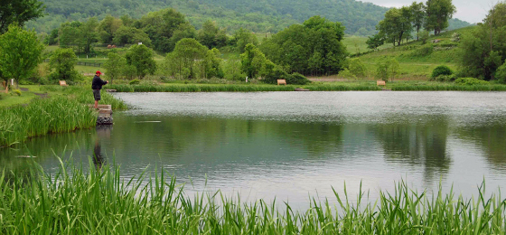
FISHING, BOATING
The park's 3.5-acre Turner Pond has fishing piers and picnic tables. A valid Virginia State fishing license, which can be purchased online or through local retailers, is required. Virginia residents 15 and under don't need a fishing license here. Turner Pond contains largemouth bass, catfish, crappie, sunfish and bluegill. Boats are not permitted.
HORSES
No rentals, but the park has more than 10.5 miles of bridle trails for those bringing horses. State law requires visitors to carry a copy of a negative Coggins report for each horse brought to the park. There's a trailer parking lot at Lost Mountain.
Park Trail Guide
Click here for the park's trail guide.
Download (external link for use with Avenza App) the geo-referenced map
Download the geo-referenced map for this park
Nearby Attractions
- Bonjour in Paris, Virginia - The Ashby Inn and Restaurant provides a unique formal atmosphere for fine dining and lodging.
- History trails - Pick up maps in the visitor center for Virginia Civil War Trails and the Mosby Heritage Area to discover the history of the region.
- Wine and farm country - There are nearly a dozen different wineries, each with a unique atmosphere and flavor, within 15 minutes of the park. Many are family and pet-friendly, and some have art galleries. All offer scenic views. Hollin Farm and Valley View Farm are less than 4 miles from the park. Hartland Orchard, Stribling Orchard and Green Truck Farm are a little farther away.
- West via Route 50 - Explore the 170-acre grounds and trails of Virginia’s State Arboretum to see trees from around the world and native plants. Just north of Route 50 is Millwood, Virginia, home to the Burwell-Morgan Mill, a 1780s working watermill that operates May through November. Across the street from the mill is Locke Country Store. Black Penny and Red Schoolhouse antique shops are also nearby.
- Marshall and Upperville, Virginia - The towns of Marshall, south on Route 17, and Upperville, east on Route 50, are treasure troves of shops, galleries, restaurants and history. Marshall has five antique shops, two galleries, restaurants and Northern Fauquier Community Park. Upperville has a thrift shop, an antique shop, restaurants and Upperville Park.
Picnic Shelters
The park rents one shelter and an uncovered group picnic pad. Mary’s Shelter is covered and is 20 by 40 feet. It rents for $130. Isabelle’s Picnic Pad is uncovered and is 20 by 40 feet. It rents for $64. Both have 10 picnic tables, accommodate up to 60 people, and have grills and access to vault toilets. Mary’s Shelter is universally accessible. Parking spaces nor fees are included in the shelter's or pad's reservation. Parking in the Picnic Area is first come, first served. Reservation holders and their guests must pay a parking fee upon entrance to the park. Call 800-933-7275 to reserve either.
Meeting Space and Facilities
MEETING FACILITIES
This park has a small meeting room.
VISITOR CENTER, GIFT SHOP
The visitor center has nature exhibits and a gift shop. It is open Monday-Thursday, 10 a.m.-4 p.m. and Friday-Sunday, 10 a.m. - 5 p.m. (closing time changes to 4:00 p.m. daily in December and January). The Visitor Center/Gift Shop is also open on evenings when the park holds astronomy programs. It is closed on Thanksgiving, Christmas Eve, Christmas and New Year's Eve and may be closed at other times, due to inclement weather or when staff is unavailable.
The Historic Area features the mid-19th century Mount Bleak House. Click here for a schedule of guided tours of the house.
RESTAURANT
None at this park.
LAUNDRY
None at this park.
ENVIRONMENTAL EDUCATION CENTER
None at this park.
SPECIAL FEATURES
The Historic Area features the mid-19th century Mount Bleak House. The area also has a log cabin, wash house, ice house and kitchen garden. Enjoy interpretive programs year-round there and stop by the visitor center and gift shop for souvenirs and outdoor gear.
Weddings
Beautiful sunsets and breathtaking vistas make Sky Meadows ideal for weddings, especially smaller ones having historical and natural themes. Call or email the park for details.
Photography
Professional photography in the park is permitted by Special Use Permit only. To apply for a special use permit for professional photography, please download this application and email the completed form to skymeadows@dcr.virginia.gov.
Other Info
ACCESSIBILITY
- Two designated parking spaces in the historic area, three in the picnic area, one at Turner Pond and one at Lost Mountain
- Wheelchair-accessible restrooms at the visitor center and the picnic area
- Visitor center and gift shop
- Mary's Shelter and several picnic tables
- Fishing pond (no paved sidewalk access)
- Although motorized vehicles are not permitted on park trails, electric wheelchairs and electric scooters that meet the federal definition for wheelchairs are allowed to enable people with disabilities to use the trails.
NATURE, HISTORY PROGRAMS
The park offers interpretive programs, activities and special events that highlight the history, natural diversity and agricultural heritage of Crooked Run Valley. The main program season runs from March through December, but some programs are offered year-round. Highlights of the season include: the Great American Campout, held annually on the fourth Saturday in June; and the Fall Farm Days, celebrated in October.
To arrange a ranger-led field trip for your school, homeschool group, youth organization or daycare; complete and submit a Field Trip Registration Form.
For a self-guided Tree Identification hike on Snowden Trail, download the Snowden Trail Tree Identification Field Guide.
Children ages 5-12 can complete the course of study to become an official Sky Meadows Junior Ranger. Download the activity booklet here or pick one up at the park.
Download the Historic Grounds Walking Tour self-guided brochure and accompanying audio tour.
Those who are hard of hearing can enjoy an American Sign Language video tour of historic Mount Bleak House.
Click here to view all parks' events, festivals, workshops and interpretive programs. Also, here's the park's Nature Guide, a guide to the park's flora and fauna.
ASTRONOMICAL OBSERVATION
The park is designated as an International Dark Sky Park by DarkSky International. The park holds monthly astronomy programs where astronomer volunteers guide visitors on a visual tour of the celestial skies and look at deep space objects through telescopes. These programs also provide educational outreach on the importance of light conservation. View event listings for upcoming astronomy programs.
For self-guided observation, the park has designated Turner Pond as its official Dark Sky Observation Area. Here, astronomers and stargazers may practice astronomy after ordinary park hours. Please see the following guidelines for night sky viewing:
- Visitors may access the area any time of the day and after dusk. However, they must vacate the area by 2 a.m.
- Turner Pond is not available for overnight camping. Overnight camping must be done in accordance with our regular camping rules.
- Visitors must pay the regular $10 parking fee and display the yellow hang tag.
- Visitors must park in designated parking areas and walk to the “Viewing Field.”
PHOTOGRAPHY
Professional photography in the park is permitted by Special Use Permit only. To apply for a special use permit for professional photography, please download this application and email the completed form to skymeadows@dcr.virginia.gov.
CONCESSIONS
Small gift shop.
HISTORY
The settlement of the area can be attributed to the nearby Ashby's Gap, which gave settlers access to the Shenandoah Valley.
In 1731, Lord Fairfax sold a 7,883-acre tract of land just south of Ashby’s Gap to James Ball. Ball died in 1754, and his land was divided among his daughter and five grandsons. One grandson sold his land to John Edmonds in 1780. Edmonds died eight years later, and his land was divided among his five children.
Isaac Settle of nearby Paris bought land from two of those children and in 1812 built a large brick house called “Belle Grove.” In 1842, he sold Belle Grove farm to his son-in-law, Lewis Edmonds, who shortly thereafter sold 148 acres to Settle’s son, Abner, who built Mount Bleak House.
In 1868 Mount Bleak became the property of George M. Slater, who had been one of Mosby's Rangers under Confederate Col. John S. Mosby during the Civil War. Slater and his son lived there for 55 years.
The property changed owners several times in the 1900s. In 1975, Paul Mellon of Upperville, Va., purchased and donated a 1,132-acre tract to the Commonwealth for the development of a state park. Another 248 acres were acquired in 1987, thus providing a corridor to the Appalachian Trail. In 1991, Mr. Mellon donated another 248 acres, designated the Lost Mountain Bridle Trail Area.
The name Sky Meadows comes from former owner Robert Hadow, who named the property "Skye Farm" after an island in Scotland.
FRIENDS GROUP
The Friends of Sky Meadows (FOSK) is a citizen support group that helps the park serve visitors and protect park resources. FOSK also raises funds to help the park and assists with stewardship projects, educates visitors about the natural and historic importance of the park, recruits volunteers and promotes the park at outreach events. Group members have diverse interests and backgrounds. Meetings are held quarterly. Visit the Friends of Sky Meadows website or email friendsofskymeadows@gmail.com for more information.
MASTER PLAN
Master plans must be written for parks before they're built. The plans are updated at least once every 10 years thereafter. The plans cover the size, types, infrastructure and locations of facilities as well as the site's special features and resources. Three public meetings are held during the initial development of each plan. Click here for this park's master plan.
Events, Programs
- 04/18/2026 - Come Fly With Me: Model Rockets
- 04/18/2026 - Barnyard Buddies: Feeding Time on the Farm
- 04/18/2026 - Astronomy for Everyone
- 04/24/2026 - Guided Hike to the Piedmont Memorial Overlook
- 04/24/2026 - Critter Chow
- More events at this park.

Blogs
- Protecting Virginia's Dark Sky Parks from light pollution
- Where to wander this winter
- Great ways to welcome winter at Sky Meadows
- Holiday shopping at Virginia State Parks
- See Virginia’s fall colors in a whole new way: Join a ranger-led adventure
- More blogs about this park.
At a Glance


