
Read Our Blogs
Forgotten 1914 High Bridge Photographs To Be Shown
Shared by Bob Flippen, AmeriCorps Interpreter Volunteer, as Guest Blogger.
When the High Bridge steel viaduct was completed in 1914, the resident engineer for the project was New Jersey native, Willis W. Vail. He photographed and documented the construction as it progressed. Forgotten photos, consisting of 4” x 5” glass negatives, were stored away until recently discovered and acquired for High Bridge Trail State Park.
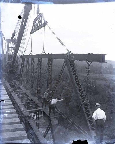
Photo of the steel span taken in 1914 by resident engineer Willis W. Vail.
On Tuesday September 20th at 7 p.m. in the Farmville Train Station, Bob Flippen, the Park’s AmeriCorps volunteer, will present for the Farmville-Prince Edward Historical Society, a PowerPoint presentation of these long lost views.
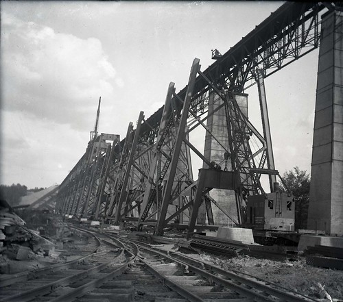
Historic photo of the bridge's steel bridge construction taken in 1914 by resident engineering Willis W. Vail.
Complementing the photos will also be excerpts from Vail’s journal that give insight into the progress of the construction and those involved with the 15-month project.
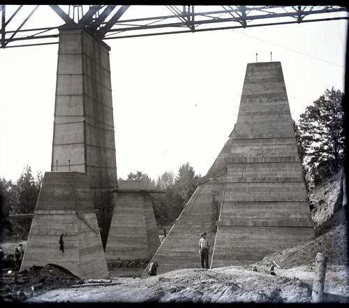
Photo taken in 1914 by Willis W. Vail shows the height of the bridge's concrete pillars.
All are welcome to attend and be among the first to see these views in nearly one hundred years. This program is offered in celebration of the 75th anniversary of Virginia State Parks. For more information, click here or call the Park Office at 434-315-0457.
High Bridge Trail is about 31 miles long and runs through Cumberland, Nottoway and Prince Edward counties and the towns of Burkeville, Farmville, Pamplin City, Prospect and Rice.
Entrances - Parking availability:
Rice's Depot Road, 1/4-mile off U.S. 460 at Rice, near trail milepost 142
River Road, three miles off N. Main St. in Farmville, near trail milepost 146
Osborne Road, 1/4-mile off N. Main St. in Farmville, near trail milepost 149
Municipal lots in Farmville where the trail intersects with Main St. near trail milepost 150
Tuggle Road, off U.S. 460 and near U.S. 15 North, near trail milepost 156
Prospect Road, off U.S. 460 at Prospect, near trail milepost 161
Elam, off U.S. 460 at Sulpher Spring Rd., near trail milepost 164
Heights School Rd., of U.S. Business 460 near Pamplin, near trail milepost 168
Latitude, 37.304488. Longitude, -78.390938.


If you have read the article and have a question, please email nancy.heltman@dcr.virginia.gov.
Search for blogs
By Park
Categories
Cabins
Camping
Fishing
History and Culture
Other
Programs and Events
Trails
Volunteers
Water Fun
Archive
2024
2023
2022
2021
2020
2019
2018
2017
2016
2015
2014
2012


