Department of Conservation and Recreation Department of Conservation and Recreation
Conserve. Protect. Enjoy.
DCR Logo
Mobile Menu
Search DCR Site
Facebook Twitter YouTube Instagram LinkedIn
About DCR
 
State Parks
 
Natural
Heritage
Soil and Water
Conservation
Recreation
Planning
Dam Safety and
Floodplains
Land
Conservation
  • Dam Safety and Floodplains
  • Grants and Funding
    • Dam Safety, Flood Prevention and Protection Assistance Fund
    • Community Flood Preparedness Fund Grants and Loans
    • Resilient Virginia Revolving Loan Fund
  • Dam Safety
    • Dam Safety Guidance Documents
    • Dam Safety Contacts
    • Dam Classification
    • Dam Safety Regulations (PDF)
    • Dam Safety Education
      • Dams 101
      • Dam Failures
      • Dam Safety Awareness Day
      • ASDSO Dam Owner Academy
      • Hurricane Season
      • Dam Safety Outreach
    • Dam Safety Training
    • Dam Safety, Flood Prevention and Protection Assistance Fund
      • 2025 Grant Awards List (PDF)
      • 2024 Grant Awards List (PDF)
      • 2023 Grant Awards List (PDF)
    • Dam Safety Inventory System (DSIS)
    • Probable Maximum Precipitation Study and PMP Evaluation Tool
    • Probable Maximum Precipitation Study Background
    • Temporal Distribution Analysis and Calculations Worksheet
    • Vegetation, Erosion
    • Rodent Control
    • Forms
  • Floodplains
    • Va. Floodplain Management Program
    • Floodplain Regulations and Ordinances
    • Virginia Flood Risk Information System
    • Natural Functions of Floodplains
    • Community Rating System
    • Floodplain Management Resources
    • Flood Awareness in Virginia
      • Flood Awareness Week
      • Outreach Resources
    • Floodplain Contacts
    • Flood Resilience Funding
      • Community Flood Preparedness Fund Grants and Loans
        • CFPF Grant Awards List
      • Resilient Virginia Revolving Loan Fund
  • Flood Resilience Planning
    • Virginia Flood Protection Master Plan
      • Get Involved
    • Virginia Coastal Resilience Master Plan
      • Coastal Resilience Master Planning Framework
      • Coastal Resilience Master Plan, Phase 1
      • Coastal Resilience Master Plan, Phase 2
      • Coastal Resilience Web Explorer
      • Web Explorer User Portal
    • Outreach and Engagement
    • Calendar, Training and Events
    • Flood Resilience Advisory Committee
    • Annual Flood Preparedness Coordination Meeting
    • Open Data Portal
    • Resources and Reports
  • Calendar, Training and Events
  • Open GIS Data Hub
  • Share your Flood Story
Home » Dam Safety And Floodplains » Flood Resilience Planning Resources and Reports

Some Virginia State Park overnight facilities will be closed from Fri., Jan. 30 through Sun., Feb. 1 . For information on which parks and other important storm related updates click here.

Flood Resilience Planning Resources


Flood Hazard Data

Understanding flood risk requires knowing which areas of your community are exposed to flooding today, and which areas are expected to be exposed in the coming decades. Due to changing patterns of precipitation, sea level rise, and development, historic flooding trends are no longer a useful predictor of future risk.

Nationwide, we lack consistent, locally specific data that forecasts flooding based on multiple risk sources. The Commonwealth is closing these data gaps and providing data tools to support flood resilience planning efforts in Virginia.

DCR flood data

DCR provides two non-regulatory flood hazard datasets that can be used together with regulatory data to support more informed flood resilience planning: a coastal Virginia flood hazard dataset (developed for the Coastal Resilience Master Plan) and a statewide Fathom flood hazard dataset (procured for the Virginia Flood Protection Master Plan). The table below explores and compares these two resources.


Coastal Virginia Flood Hazard Data

Fathom Flood Hazard Data

Geographic Area

Coastal: localities within any of the eight easternmost Planning District Commissions in Virginia.

Statewide: The entire Commonwealth of Virginia.

Flood Hazards

Coastal, riverine, and rainfall-driven flooding

Coastal, riverine, and rainfall-driven flooding

Recurrence Intervals

Seven recurrence intervals: 1 in 2-, 5-, 10-, 25-, 50-, 100-, and 500-year.

Three tidal conditions (MLW, MHW, 1.5xMTR) are also available for coastal flood data.

Five recurrence intervals*: 1 in 10-, 25-, 50-, 100- and 500-year.

Associated DCR Plan

Coastal Resilience Master Plan (CRMP)

Virginia Flood Protection Master Plan (VFPMP)

Planning Scenarios

Five planning scenarios: baseline (2020), plus “moderate” and “high” scenario options for the near future (2030-2060) and far future (2060-2100) time horizons.

Five planning scenarios: baseline (2020), plus two “moderate” and “higher” scenario options for the 2060- and 2100-time horizons.

Basis for Future Conditions

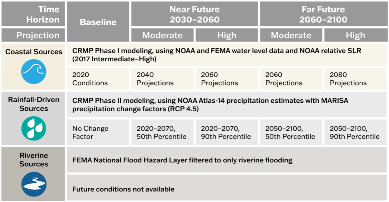
Varies by flood source and planning scenario. See reference figure for more information.

Shared Socioeconomic Pathway 2-4.5 (SSP2-4.5). “Moderate” scenario based on median (50th percentile) values and “higher” scenario based on 83rd percentile values.

 Resolution

10-foot

10-meter (~33-foot)  

Source

DCR with underlying data from the United States Army Corps of Engineers, the National Oceanic and Atmospheric Administration, and the Federal Emergency Management Agency.

Fathom

Access

View and download data and methodology documentation via DCR’s Flood Resilience Open Data Portal.

View the 1 in 100- and 500-year data for baseline conditions via DCR’s Flood Resilience Open Data Portal.

Access to all other products is provided to VA public institutions.*

Additional Information

Learn more via the one-pager.

Learn more via the one-pager.

*Virginia government entities and state-recognized Tribal governments may sub-license all Fathom data from DCR for a 12-month renewable license term. To inquire about a sub-license agreement, including data use limitations, please contact us at flood.resilience@dcr.virginia.gov.

Other flood data

Additional data to visualize and understand flood hazards is available through state and federal platforms. Below is a snapshot of these data resources which can be accessed through the links provided.

  • FEMA Flood Hazard Data via DCR’s Virginia Flood Risk Information System (VFRIS) – VFRIS compiles and displays flood hazard data from the Federal Emergency Management Agency (FEMA) including Special Flood Hazard Areas. It also provides access to links to download FEMA Flood Insurance Studies, FEMA HEC-RAS Models. These maps also display non-regulatory flood hazard data including data from  and data do not incorporate future-looking projections based on changing precipitation patterns, new development or compound flood risk from tidal flooding events.

  • National Hurricane Center’s Storm Surge Risk Maps – includes data viewers and data downloads based on modeling which forecasts the extent and depth of storm surge resulting from hurricanes (category 1-5) for the Virginia coast. 

  • NOAA 2022 Sea Level Rise Technical Report – provides nationwide forecasts for sea level rise through 2150. The report provides more recent forecasts than were included in DCR’s coastal resilience web explorer and Phase I of the Coastal Resilience Master Plan. NOAA’s Sea Level Rise Viewer allows users to map and download the data.

  • NOAA Mid-Atlantic RISA Projected IDF Curve Data Tool – county-level tool for forecasting changes in precipitation depths from historic ATLAS-14 modeling to two future conditions (2020-2070 and 2050-2100) under two emissions scenarios (RCP 4.5 and RCP 8.5). The model forecasts precipitation change across six average recurrence intervals (2-year to 100-year) and 14 durations (5 minute to 7 day).

Tools for Planning

There are many tools to aid organizations in crafting a flood resilience plan. Below is an abbreviated list of useful planning tools. Additional tools can be found on the information gateways linked below.

Tools specific to Virginia

The following tools were developed with Virginia-specific needs in mind. While some are focused on exploring flood resilience specifically, others support resilience planning more broadly.

  • CFPF Resilience Plans - a DCR-approved Resilience Plan is required for localities submitting applications in the "project" category of the Community Flood Preparedness Fund. The requirements for an approved resilience plan can be found in Appendix F of the CFPF Grant Round 6 draft manual.
  • ADAPT VA – an information gateway on climate change adaptation for individuals, local programs, and agencies in Virginia. The website provides a variety of resources such as short and long-term sea level curves and maps, flood mapping and decision-support tools, legal and policy resources, and stories that explain adaptation through maps and pictures.
  • Proactive Planning for Resilience: Protocols for Community-Led Climate Adaptation Planning in Virginia – a Virginia-specific guide for climate adaptation planning for decision-makers across the Commonwealth. The website outlines steps for developing a plan, with detailed case studies, definitions, tools, legal considerations and best practices.
  • The RAFT and PREP Tool – The Resilience Adaptation Feasibility Tool (RAFT) Team is a Virginia state university partnership which brings capacity building and technical assistance to local governments over a period of 18 months to help build their resilience. Their team’s PREP Tool provides access to the RAFT’s methods and approach for assessing local government capacity for resilience and identifying and prioritizing projects to implement.

Federal Tools

Federal agencies have developed tools to assist organizations to plan and implement successful flood resilience strategies. The following resources may help you to craft your resilience plan.

  • US Climate Resilience Toolkit – a national portal that includes a variety of tools for building resilience to flooding impacts, including the Steps to Resilience Framework, which outlines a straightforward process for creating a resilience plan alongside resources to use to get there.
  • USACE’s International Guidelines on Natural and Nature-Based Features for Flood Risk Management – consolidates best practices for constructing natural and nature-based features for flood risk management into a guidance document for decision-makers and practitioners to use when considering these practices in flood resilience plan development.
  • US DOI Nature Based Solutions Roadmap – outlines information on nature-based solutions, including specific strategies, considerations for implementation, co-benefits, examples, and resources.

Information Gateways

These portals and databases contain a variety of resources – such as data, planning tools and funding information – that may be useful to your organization as you develop your resilience plan:

  • FEMA Recovery and Resilience Resource Library
  • Association of State Floodplain Managers’ Library
  • National Wildlife Foundation, Nature-Based Solutions Funding Database

Funding for planning and implementation

Organizations developing flood resilience plans should consider approaches which align both with DCR’s flood resilience plan guidance, as well as with federal resources and funding opportunities. Resources to help you understand how to align your approach to resilience planning with available funding resources include:

DCR Flood Resilience Funding Resources

DCR administers the Community Flood Preparedness Fund (CFPF) and the Resilient Virginia Revolving Fund (RVRF).  For more information on these funds visit the DCR Floodplain Management, Flood Resilience Funding website.
Beyond the DCR administered resilience funds, the Coastal Resilience Web Explorer Funding Opportunities tab provides an inventory of funding sources that may be available to finance the development and/or implementation of your plan. While it is catered to the coastal region, non-coastal activities may be eligible for some listed opportunities.
The DCR Flood Resilience Funding Geographic Focal Area Viewer identifies geographic areas that are designated as either required or preferred for resilience funding, including Low-Income Geographic Areas for the DCR Community Flood Preparedness Fund.

Other Funding Resources

  • Federal Emergency Management Agency (FEMA) and Virginia Department of Emergency Management (VDEM)
    • FEMA Hazard Mitigation Assistance Guidance
    • VDEM Grants Program Information
    • COVA Hazard Mitigation Plan
  • United States Army Corps of Engineers (USACE)
    • Flood Risk Management Mission to learn more about the Corps’ available assistance programs.
    • Division and District Information to determine the appropriate point of contact to learn more.  USACE is broken into watershed-based divisions and districts.
  • Others
    • American Flood Coalition Flood Funding Finder
    • U.S. Climate Resilience Toolkit Funding Resources

Reports

Historic reports relevant to flood resilience planning in Virginia are archived via the dropdown menus below.

2025 Resilience in the Commonwealth of Virginia Status Update

During the 2024 General Assembly session, House Bill 1458 amended the Status of Flood Resilience Report requirements in the Code of Virginia (§ 2.2-220.5) to include the status of overall resilience in the Commonwealth, including flood resilience. Released in July 2025 and every two years thereafter, the report includes the status of actions undertaken by the Chief Resilience Officer and state agencies regarding resilience coordination and planning and all resilience funding received and distributed by the Commonwealth during the prior two years.

Read the 2025 Resilience in the Commonwealth of Virginia Status Update

2023 Resilience Coordination Working Group Report

During the 2024 General Assembly session, House Bill 1458 amended the Status of Flood Resilience Report requirements in the Code of Virginia (§ 2.2-220.5) to include the status of overall resilience in the Commonwealth, including flood resilience. Released in July 2025 and every two years thereafter, the report includes the status of actions undertaken by the Chief Resilience Officer and state agencies regarding resilience coordination and planning and all resilience funding received and distributed by the Commonwealth during the prior two years.

  • Download the full Resilience Coordination Working Group Final Report and Recommendations
  • Download the abbreviated Resilience Coordination Working Group Final Recommendations

The Virginia Commonwealth University (VCU) Center for Public Policy (CPP) facilitated the RCWG with financial support from the Commonwealth Center for Recurrent Flooding Resiliency (CCRFR).

2023 Status of Flood Resilience Report

In 2023, the Commonwealth’s Chief Resilience Officer published a biennial report to the Governor and General Assembly on the status of flood resilience in Virginia in accordance with the Code of Virginia (§ 2.2-220.5).

Read the 2023 Status of Flood Resilience Report.

Home » Dam Safety and Floodplain Management » Flood Resilience Planning
Virginia Department of Conservation and Recreation
600 East Main Street, 24th floor | Richmond, VA 23219-2094 | 804-786-6124
Please send website comments to web@dcr.virginia.gov
Address general inquiries to pcmo@dcr.virginia.gov
Copyright © 2026, Virginia IT Agency. All Rights Reserved
Last Modified: Wednesday, 21 January 2026, 10:38:47 AM
eVA Transparency Reports View the Virginia Department of Conservation and Recreation's expenditures.
Contact Us | Media Center | Privacy Policy | ADA Notice | FOIA | Jobs | Code of Ethics (PDF)
DCR Organizational Chart (PDF) | Strategic Plan (PDF) | Executive Progress Report (PDF) | Public Safety & Law Enforcement