Department of Conservation and Recreation
Conserve. Protect. Enjoy.
Department of Conservation and Recreation


If you are willing to fill out a quick survey about your use of this and other Virginia ConservationVision models, please click here. This will also enable you to sign up for notifications about model updates.
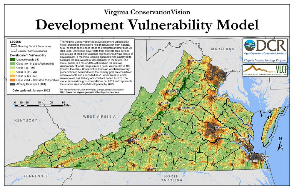
The purpose of the Virginia ConservationVision Development Vulnerability Model is to quantify the risk of conversion from greenspace (natural, rural, or other open space lands) to urbanized or other built-up land uses. The model output is a raster dataset in which the relative vulnerability of lands ranges from 0 (least vulnerable) to 100 (most vulnerable). Vulnerability values are not probabilities, but should be interpreted as a relative measure of development potential. Conservation lands on which biodiversity preservation is believed to be the primary goal are considered undevelopable and are coded with the value -1, while areas in which development has already occurred are coded 101.
The basis of the model is a Random Forest machine-learning model, used to relate a suite of predictor variables representing conditions at an initial time to outcomes (developed or not) a decade later. The predictor variables can be grouped into three categories based on their spatial focus: (1) local site characteristics, (2) neighborhood characteristics, and (3) travel time or distance to development "attractors". The sampling frame was limited to areas that were undeveloped at the initial time but that could potentially be developed in the future.
To train and test the model, predictor variables representing conditions in the year 2006 were connected to outcomes in 2016, with the data split into independent subsets used for training and testing. Once the prediction model was finalized, variables representing conditions in 2019 were used to predict the relative potential for development by the year 2029. To produce the final vulnerability map, raw prediction values were adjusted to reflect the status of lands that are currently protected or already developed.
This model is one of several in a suite of conservation planning and prioritization models developed by the Virginia Natural Heritage Program and partners, known collectively as Virginia ConservationVision. It is intended for use in conjunction with other data to help target lands for protection. The model can also serve as an input for simulating future land cover change and its consequences under different planning scenarios.
For an overview of how this model was produced, see this slide show.
For details, refer to the technical report which includes:
The following datasets can be downloaded as ArcGIS Pro layer packages, which include a raster dataset (TIF format, 30-m pixels). For non-ArcGIS Pro users, layer packages can be extracted using 7-zip software.
High-resolution maps (PDF or PNG format) and alternative raster data formats are available on request.
A number of models predicting the probability of development have been produced by other entities, and some of these cover all or portions of Virginia as part of a larger region. Outputs from some of these models include: