Department of Conservation and Recreation
Conserve. Protect. Enjoy.
Department of Conservation and Recreation


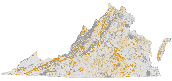
Virginia’s agriculture and forestry industries contribute a combined $91 billion annually to Virginia’s economy and generate more than 450,000 jobs throughout the Commonwealth. Whether it is beer, wine, equine, aquaculture, timber or livestock – Virginia’s agricultural and forestry products are enjoyed locally, used throughout the country and exported around the world. To support this important industry, it’s important that Virginia conserve high value agricultural and forest lands that face potential development. A total of 6.09 million acres of agricultural and forest lands are included across the seven ConserveVirginia categories.
The Agriculture & Forestry Category identifies priority agricultural and forest lands across Virginia and was developed under the Secretary of Agriculture and Forestry. It is comprised of two datasets one for agriculture and one for forestry. The Agriculture dataset identifies agricultural lands across Virginia that are threatened by development, as well as provides a spatial dataset that represents the land’s agricultural potential. The Agriculture dataset is comprised of data from the American Farmland Trust (AFT) Farms Under Threat: State of the States project, version 2.0. The Farms Under Threat State of the States spatial data includes a detailed assessment of the extent, diversity, location, and quality of agricultural land in the United States, as well as the threats to this land from expanding commercial, industrial, and residential development. The results of this effort include: An agricultural land cover dataset with rangeland, pastureland, cropland and woodland land cover classes, an index of agricultural land Productivity, Versatility, and Resiliency (PVR), and a valuation of the impact of low density residential development and urban high density development on agricultural land. The PVR score is biased towards human-edible food crops and does not consider land that may be viable for urban agriculture, proximity to points of infrastructure (processing facilities, ports, roads, etc.), or livestock production. Priority lands were selected based on the following percentages: Coastal 16.9%, Piedmont 44.2% and Mountain 38.9%.
The Department of Forestry’s Forest Conservation Value (FCV) Model strategically identifies priority forestland in Virginia for conservation by identifying those of the highest quality, most productive, and most vulnerable statewide. The model classifies forestlands based on watershed integrity; size of forested blocks; management potential; connectivity and proximity to other conserved lands; threat of conversion, and diminished tree species and significant forest community attributes. The model assigns a relative FCV rank to all forestland in Virginia from 1 (lowest) to 5 (highest); the highest class was used for the Strategy. The ConserveVirginia mapped lands include large blocks, and clusters incorporating smaller patches, of high quality forest with overall high FCV. The data resource areas in the Agriculture & Forestry Category represent a total of 1,583,249 acres.
| Agriculture | YES/NO – high priority agricultural areas are included |
| Forestry | YES/NO - high priority VDOF-identified forested areas are included |
| Map Date | Map creation date |
| Deed Requirement | Required protections to meet ConserveVirginia standards |
Help Documents
How to use the Natural Heritage Data Explorer for interactive versions of all ConserveVirginia maps.
View a Demonstration Video
How to use interactive ConserveVirginia maps on the Virginia Natural Heritage Data Explorer.