Open fires are prohibited throughout the park from midnight to 4 p.m., Feb. 15 through April 30. Learn more.
New River Trail State Park
116 Orphanage Dr., Max Meadows, VA 24360; Phone: 276-699-6778; Email: NewRiverTrail@dcr.virginia.gov
Latitude, 36.884589. Longitude, -80.852549.


Photos and video


This content takes priority over any other information provided on this park's webpage.
The park is open daily from dawn to dusk. Please view the current map to access only the open portions of the trail.
The park office is open Monday - Friday 8 a.m. - 4:30 p.m., closed state holidays. Call for the current schedule for the Cliffview office.
Depot Gift Shop:
Until May 26: Monday-Thursday, 9 a.m.-4 p.m; Friday-Sunday, 9 a.m.-6 p.m.
After Memorial Day: Monday-Thursday, 9 a.m.-5 p.m; Friday-Sunday, 9 a.m.-6 p.m.
Boat and Bike Livery:
April 1-Memorial Day: Friday-Sunday, 9:30 a.m.-5:30 p.m.
Memorial Day-Labor Day: Daily from 9:30 a.m.-5:30 p.m.
After Labor Day-Oct. 31: Friday-Sunday 9:30 a.m.-5:30 p.m.
Nov.-March: closed
Contact Station: open for the season. Parking is $7 per standard vehicle. When the contact station is not staffed, use the self-pay envelope for cash or check and place in the honor safe. Credit cards can be used in the park office when open or by using the QR code self-pay app.
Shot Tower:
Shot Tower grounds are open from dawn to dusk.
Tours are unavailable due to renovations. Standard parking fee applies.
The Inn at Foster Falls is temporarily closed. We hope to reopen by May.
Please review the Virginia State Parks Know Before You Go information before you visit.
General Information
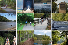
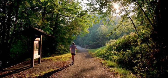
New River Trail is a 57-mile linear park that follows an abandoned railroad right-of-way. The park parallels the scenic and historic New River for 39 miles and passes through four counties and the city of Galax.
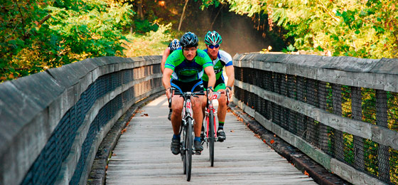
The trail's gentle slope makes it great for visitors of all ages to hike, bike and ride horseback. The park's Foster Falls area offers canoe and bike rentals, boat launches and gift shops. Fishing is popular from the banks of the New River. Extend your visit by reserving a primitive campsite or enjoy the comfort of the Inn at Foster Falls for a boutique lodging experience. The park's Hoover Mountain Biking Area is also popular with those seeking extra adventure.
There are access points to the trail at Allisonia, Chestnut Yard, Cliffview, Dannelly Park (near Galax), Draper, Dora Junction (near Pulaski), Foster Falls, Fries, Galax, Gambetta, Hiwassee and Ivanhoe. Horse trailer parking is available at Allisonia, Austinville, Cliffview, Dora Junction, Draper, Fries, Ivanhoe and the Mark E. Hufeisen Day Use Area.
- Two tunnels: 135 feet and 193 feet long
- Three major bridges: Hiwassee - 951 feet; Ivanhoe - 670 feet; Fries Junction - 1,089 feet
- Nearly 30 smaller bridges and trestles
- A historic shot tower used more than 200 years ago to make ammunition
- Potable water is available only at Galax, Cliffview Campground (Dannelly Park) and Foster Falls as well as at the horse trailer lots at Ivanhoe, Draper and Dora Junction.
- Five non-flush toilets are available along the trail.
Hours
Trails and the day-use area are open daily from dawn to dusk. Call the park for livery and gift shop hours.
Location
There are several entrances into this park. The park meanders through Grayson, Carroll, Wythe and Pulaski counties and Galax in southwestern Virginia and parallels the scenic and historic New River for 39 miles.
Its address is 116 Orphanage Dr., Max Meadows, VA 24360.
Foster Falls: Latitude, 36.530512. Longitude, -80.512931.
Shot Tower: Latitude, 36.522000. Longitude, -80.522033.
Cliffview: Latitude, 36.408613. Longitude, -80.550665.
You may use cash, check or Visa, MasterCard, Discover, or American Express at self-pay lots.
Localities:
Counties: Carroll, Grayson, Pulaski and Wythe
Cities: Galax
Towns: Allisonia, Austinville, Draper, Fries, Hiwassee, Ivanhoe and Pulaski
Here's a list of entrances, directions and points of interest.
Drive Times: Charlotte, N.C., 2 hours; Knoxville, Tenn., 3 hours; Winston-Salem, N.C., 1 hour.
Park Size
1216.6 acres.
Follow us

Cabins, camping
OVERNIGHT FACILITIES
Camping; no cabins. Overnight accommodations are available at the Inn at Foster Falls. The park has three campgrounds in different locations with different types of sites. Please read the following information carefully and follow instructions specific to the campground of interest. Other locations are for day-use only.
For information on the availability of overnight accommodations, particular park amenities, or to make a reservation at a campground, you can reserve online or call 1-800-933-PARK. Rental rates for cabins and camping vary by season, dwelling, site type and park. First, determine the appropriate season, which can vary by park, then the relevant rate. You also may want to learn about the cancellation and transfer policies.
The Inn at Foster Falls is closed. We look forward to welcoming guests in spring 2026.
Camping
New River Trail State Park has three primitive campgrounds: Cliffview, Millrace and Double Shoals. There's no vehicular access to the campsites and no showers or bathhouses.
Cliffview Campground (Carroll County near Galax) is a trailside campground with primitive tent camping only. It overlooks Chestnut Creek. Access is from the Dannelly Fitness Complex parking lot and across a footbridge (no direct vehicle access). Twelve primitive campsites are available. Note: This campground is 24 miles from the Millrace Campground.
All sites are timbered and marked. Each site has a fire ring, lantern post, picnic table, access to the New River Trail and non-flush toilet. Drinking water is available. One site, CV001, is universally accessible and is reserved last if not required for a disabled camper.
Reservations are required. Same-day reservations are permitted. Campers must leave their confirmation letter on their car's dashboard for overnight parking. Campers will need access to a fax machine or will need to pick up the letter at the Cliffview office if there is insufficient time to receive the letter by mail.
Running water at Cliffview Campground is shut off from November through March. Customers must bring water during that time.
Directions: Take State Route 58 to Galax. Go north on SR 887 to Cliffview Road (SR 721). Take SR 721 one-quarter of a mile and turn right onto Creekview Road. Go one mile to the Dannelly Complex. Cliffview Campground parking is on the right. Cross the footbridge into the campground.
Number of sites of each type: Primitive Tent, 12
Site types:
CV001-CV012: Site CV001 is universally accessible and is the last to be rented if not required by a disabled guest.
Millrace Campground (Wythe County at Foster Falls). This campground overlooks the New River. There is no vehicular access to the campground. There is a short hike to the sites from the parking lot. There are 19 primitive tent camping sites. Note: This campground is 24 miles from Cliffview Campground.
All sites are timbered and marked. Each has a fire ring, lantern post, picnic table, access to the New River Trail and non-flush toilet. Drinking water is available. One site, MR019, is universally accessible and is reserved last if not required for a disabled camper. There is no life-guarded swimming. The New River's current is unpredictable and potentially dangerous; underwater hazards are possible.
Reservations are required. Same-day reservations are permitted. Campers must leave their confirmation letter on their dashboard for overnight parking. Campers will need access to a fax machine or need to pick up the letter at the Foster Falls office if there is insufficient time to receive the letter by mail.
Directions: From I-77, take Exit 24. Go east on State Route 69 to SR 52. Go north to SR 608. Go east and follow signs.
Number of sites of each type: Primitive Tent, 19
Site Type:
MR001-MR019: Site MR019 is ADA (universally accessible). This site is reserved last if not required by a disabled citizen.
Double Shoals Campground is an honor system campground. There's a self-pay system onsite for first-come, first-served use. Two primitive sites only. Campers must bring their own water. It is part of the New River Canoe Trail and is accessible only by river or trail via paddling or hiking. The Town of Fries is the closest access. Location is mile marker P-40 on the Fries branch of New River Trail State Park. Land neighboring Double Shoals is privately owned and landowners do not accommodate parking.
Recreation
TRAILS
The 57-mile multi-use trail is great for hikers, bikers and horseback riders. Those seeking extra adventure will love the Hoover Mountain Biking Area. It has five loops with seven trails, which are off-limits for horses and golf carts. All trails are rated easy or moderate. Access is between the Allisonia Boat Ramp and Hiwassee River Bridge on Julia Simpkins Road in Allisonia. See an enhanced map of the area.
SWIMMING
There are no designated swimming areas, but tubing the New River is popular here. Call the Foster Falls Boat and Bike Livery at 276-699-1034 to rent tubes.
FISHING, BOATING
This linear park parallels a 39-mile stretch of the New River. Boat ramps are available at Allisonia, Foster Falls and Austinville. The river supports outstanding populations of just about every major freshwater game fish in the state. You’ll find smallmouth bass, spotted bass, largemouth bass, rock bass, striped bass, white bass, hybrid striped bass, muskellunge, walleye, black crappie, channel catfish, flathead catfish, yellow perch, redbreast sunfish and bluegill. State records caught in the New River include muskellunge (45 pounds, 8 ounces), smallmouth bass (8 pounds, 1 ounce) and yellow perch (2 pounds, 7 ounces). The state record spotted bass came (3 pounds, 10 ounces) from nearby Claytor Lake. The New River is bound to yield many more record-setting catches in the future.
The park also rents kayaks and canoes at the Foster Falls Boat and Bike Livery, opened seasonally on Fridays, Saturdays, and Sundays from April to Memorial Day and is open seven days a week from Memorial Day to Labor Day and Fridays, Saturdays, and Sundays again from Labor Day through October. Download a Boat & Bike flier. For more information, please call 276-699-1034.
Visit this site for detailed New River maps and trip planning information.
HORSES
Bringing your own horse? Except for a two-mile section from Galax to Cliffview, the trail is available for horseback riding. Horse trailers must be parked at the Austinville, Cliffview, Draper, Fries, Ivanhoe, Pulaski (Dora Junction) and Mark E. Hufeisen Day Use Area (Foster Falls) entrances only. State law requires that visitors carry a copy of a negative Coggins report with each horse brought to the park.
The Mark E. Hufeisen Day Use Area is easily accessible from Interstate 77. Take exit 24, Poplar Camp, to Rt. 69 Lead Mines Road to Highway 52 north. About 2 miles later, turn right onto Foster Falls Road and take the first left.
Park Trail Guide
Click here for the park's trail guide.
Download (external link for use with Avenza App) the geo-referenced map
Download the geo-referenced map for this park
Nearby Attractions
Pulaski County
- Town of Pulaski
- Claytor Lake State Park
- Draper Mercantile
- Gatewood Park
- Jefferson National Forest
- Motor Mile Speedway
- Wilderness Road Regional Museum
- Randolph Park
- The New River Valley Fairgrounds has many events and activities year-round.
Wythe County
- Wythe County Chamber of Commerce
- Wohlfahrt Haus Dinner Theatre
- The Fort Chiswell Mansion
- Wolf Creek Indian Village and Museum (Bland, VA 42 minute drive)
- Hungry Mother State Park is within an hour's drive.
- Wytheville Training School
Carroll County
- Twin County Regional Chamber of Commerce
- Blue Ridge Parkway
- Beaver Dam Creek Trail
- Blue Ridge Country Club
- Carter Pines Community Park
- Crooked Creek Wildlife Management Area
Galax
- The city of Galax
- Take an art, craft or music class at the Chestnut Creek School of the Arts
- Barr’s Fiddle Shop,
- Blue Ridge Music Center
- Old Fiddler’s Convention
- Galax Recreation Center
- The Crooked Road
- The town of Fries
Grayson County
- Visit Grayson County
- Grayson Highlands State Park
- Mount Rogers National Recreation Area
- Matthews Living History Farm Museum
- Virginia Creeper Trail
- The town of Fries
Itineraries
Sentimental Skeeterdogs
Camping, Captains and Camels
Eats, Beats and More
Picnic Shelters
Shelter 1: This shelter accommodates up to 75. It's 30 x 70 feet and is universally accessible. A portable toilet is nearby. Vehicles must be parked in the nearby parking lot. The shelter has a charcoal grill. Shelter guests must still pay the daily parking fee.
This shelter is at the Foster Falls playground and picnic area and is available for rent year-round. It may be rented all day (8 a.m. - 10 p.m.). Call (800) 933-PARK to reserve this shelter. Parking fees are not included in shelter or amphitheater rental (see above for details).
Shelter 2: This enclosed shelter accommodates up to 50. No vehicular access - a short hike is required to reach it. Vehicles must be parked at the Depot or amphitheater. Call 276-699-6778 to rent. Rental does not include the daily parking fee.
Cancellation policy for amphitheater and shelter: No refunds within 14 days before the reserved date. Before then, there's a cancellation fee. Transfers may be made but only during the reservation center's normal operating hours Monday through Friday, prior to the arrival date. Refunds will not be given on the reservation date to customers who have not transferred their reservation ahead of time or canceled their reservation at least 14 days beforehand.
New River Amphitheater at Foster Falls-Millrace: The amphitheater is open year-round and rents for the entire day. Customers must contact the park for a Special Use Permit after reserving the amphitheater. It helps the park prepare for the given event - wedding, music, organized event, etc. Also, customers should call the park at (276) 699-6778, the day before their event takes place to discuss payment of their guests' parking fees. (The park's normal parking fee is charged for guests attending amphitheater functions. The reservation covers only rental of the amphitheater.) Picnicking isn't allowed in the amphitheater. Because no vehicles are allowed in Historic Foster Falls Village, there's no vehicular access directly to the facility. The closest vehicular access is about 35 feet away.
The amphitheater seats up to 300 with standing room for about 100 more. There are six 110-volt outlets for the stage area. The stage is 24 by 40 feet. There are two dressing rooms, each 12 by 20 feet, behind the stage. There are no restrooms here. The nearest restrooms, which are closed during winter, are at the Foster Falls Depot Gift Shop. Portable toilets are available year-round.
Meeting Space and Facilities
MEETING FACILITIES
Meeting facilities are available at the Inn at Foster Falls. The Inn at Foster Falls is closed. We look forward to welcoming guests in spring 2026.
VISITOR CENTER, GIFT SHOP
This park has a gift shop in Cliffview and Foster Falls.
RESTAURANT
Overnight accommodations are available at the Inn at Foster Falls. The Inn at Foster Falls is closed. We look forward to welcoming guests in spring 2026.
LAUNDRY
None at the park.
Restaurants nearby
- Galax: Applebee’s, 276-236-2905; Macados, 276-236-0399; Smokehouse, 276-236-1000
- Fries: The Windy River Café, 276-744-0137; New River Side Store & Deli, 276-768-8522
- Max Meadows; Happy 5 de Mayo, 276-637-1100
- Wytheville: Log House 1776 Restaurant, 276-228-4139; Applebee’s, 276-223-4404; Cracker Barrel, 276-228-1046
- Draper: The Draper Mercantile and Trading Company, 540-994-5659
- Pulaski: Compadres Mexican, 540-994-3557; Chang Hua Chinese, 540-980-6363
ENVIRONMENTAL EDUCATION CENTER
The Discovery Center at Foster Falls has a small indoor theater, aquariums, terrariums, and mounted fish and wildlife. Educational programs and activities, including crafts, touch tables, critters in the creek, film viewing and more, are held here throughout the year. A wet lab is being built. See park events for details.
SPECIAL FEATURES
Shot Tower, tunnels, trestles, Chestnut Creek and the New River. Learn about weddings at New River Trail.
Other Info
ACCESSIBILITY
- Trail: The entire length of the trail is accessible with all trail side picnic/rest areas, including accessible tables. Five trail side non-flush restroom facilities are accessible.
- All-terrain wheelchairs are available. See the park map for ATW trails
- Camping: One accessible site each at Millrace and Cliffview campgrounds, and these campgrounds include accessible non-flush restroom facilities.
- Cliffview office, Foster Falls depot, Foster Falls concession building, and Foster Falls picnic shelter are all accessible. Two non-flush restroom facilities at the Foster Falls access are accessible, and one restroom facility at the Cliffview access is accessible.
- Shot Tower accessibility: The Shot Tower grounds and restroom facilities are accessible. Although climbing the Shot Tower is not an accessible feature, the park provides a picture showcase that allows those unable to climb the tower to see the views at the top of the tower.
NATURE, HISTORY PROGRAMS
View all parks' events, festivals, workshops and interpretive programs.
CONCESSIONS
The Foster Falls Boat and Bike Livery is open on weekends from the first Saturday in April through Memorial Day, then open daily, Memorial Day through Labor Day, and open on weekends again Labor Day through the last Sunday in October. The livery rents canoes, kayaks, tubes, bikes and safety equipment and offers shuttle service, snacks and drinks—Call 276-699-1034 for details.
HISTORY
In December 1986, Norfolk Southern Corporation donated a 57-mile tract of abandoned railroad right-of-way to the Commonwealth of Virginia to establish a new state park. Because railroad tracks had previously been on the strip of land, the cinder roadbed needed minimal grading. With the help and support of volunteer groups and chambers of commerce in the region, the park opened in May 1987 with four miles of trail. Since then, approximately 57 miles of the park have been open to the public.
FRIENDS GROUP
The Friends of New River Trail are citizen volunteers supporting New River Trail State Park’s mission and operations throughout the region and state. We are dedicated to fostering friendships and partnerships in maintaining our state park as a premiere rail-to-trail park. Our Friends seek to further the development of educational programs that focus on the natural and cultural history of the region, outdoor recreational opportunities and conservation stewardship of the park for all groups and provide entertaining programs for all ages. Annual membership dues for voting members are set at $10 individual, $15 family and $5 student. However, anyone may participate in our meetings as non-voting members without making a donation. Donations are accepted in any amount for support of our projects and programs. In addition, we ask that volunteers record all their volunteer time with Virginia State Parks, Department of Conservation and Recreation’s volunteer database system. This is one way the state gauges support for its park.
Volunteers can earn awards as a “Thank You” for their time and efforts at the park. Benefits are awarded according to the hours accumulated and range from annual parking passes to camping and cabin privileges.
Located in the counties of Carroll, Grayson, Pulaski, and Wythe, City of Galax and the Towns of Fries and Pulaski, New River Trail State Park offers visitors a variety of recreational opportunities amid the beautiful landscape of the New River and Chestnut Creek waterways. The park offers picnicking, primitive camping, fishing, boating, tubing, swimming, playgrounds, hiking, biking and horseback riding.
For more information visit: https://friendsofnrt.com
MASTER PLAN
Master plans must be written for parks before they're built. The plans are updated at least once every 10 years thereafter. The plans cover the size, types, infrastructure and locations of facilities as well as the site's special features and resources. Three public meetings are held during the initial development of each plan. Click here for this park's master plan.
Events, Programs
- 04/18/2026 - Art in the Park
- 04/18/2026 - B.A.R.K. Ranger Walk
- 04/19/2026 - Wild Plants of SWVA Walk
- 04/22/2026 - Women's Walking Group
- 04/22/2026 - Volunteer Call to Service Earth Day Event: Transplanting Rivercane + Trash Pickup
- More events at this park.

Blogs
- Bikepacking New River Trail State Park: Q&A with Misty Prewitt
- Trail etiquette on Virginia State Parks' rails-to-trails
- Where community came before country: A love letter to New River Trail State Park
- 5 winter adventures at New River Trail State Park
- New River Trail State Park opens first Kids TRACK Trail
- More blogs about this park.
At a Glance


