Department of Conservation and Recreation
Conserve. Protect. Enjoy.
Department of Conservation and Recreation


Habitat loss is the greatest threat to biodiversity. Conversion of natural land to residential and commercial development is the primary mechanism by which habitat is lost permanently in Virginia. Without proper planning, this conversion can occur in decentralized and scattered patterns, consuming an excessive amount of land and causing unnecessary fragmentation of the landscape. Such has been the case in Virginia in recent decades and the consequences include not only lost habitat and natural corridors but also the degradation of important ecosystem services that keep our air and water clean, assist in climate regulation, and reduce the impacts of natural disasters.
Fragmentation of the landscape also takes an immeasurable toll on Virginia's biodiversity; roads and other development have reduced the number of large patches of natural vegetation in Virginia. Such large patches have greater benefits than the same total area of natural vegetation when distributed among smaller patches. One of these fundamental benefits pertains to the species-area relationship in which the richness of species increases progressively with habitat size. In general, biodiversity approximately doubles with every tenfold increase in habitat area. Large patches tend to have greater variety of habitats and more protection from disturbance from adjacent areas. Thus they tend to have higher numbers of species than small patches. Large patches also are important for their ecosystem services, including filtering nutrients and pollutants from water, preventing erosion, retaining soil, providing pollinators for crops, removing carbon from the air and sequestering it in woody biomass, slowing a and absorbing runoff so groundwater is recharged, absorbing solar energy and keeping local areas cooler, and providing protection from storm and flood damage. Ecosystem services often are overlooked as landscapes are developed largely because traditional economic analyses that incorporate the financial benefits of development usually do not include the financial benefits of ecosystem services. Studies have estimated that these services contribute as much or more to the global economy as do marketplace processes (Costanza et al. 1997) and that they can result in a return on investment in excess of 100 to 1 when natural lands are conserved (Balmford et al. 2002). These financial benefits are further increased when considering the recreational opportunities natural lands provide and the tourism revenues they generate.
Certain species require cover deep within the interior of continuous habitat that is far away from natural or human-induced edges. These core areas, which for sensitive interior species may be many times the size of their home ranges, insulate species from edge effects that adversely affect their ability to survive and reproduce. For forest dwelling birds, these edge effects include nest and adult predation by edge-inhabiting species such as raccoon, striped skunk, red fox, American Crow, and Blue Jay, which usually are not found in extensive forests with a high proportion of interior conditions. Where suburban development is juxtaposed with natural land, the domestic cat can be a significant source of predatory losses for birds and small mammals. Another edge effect causing significant declines in songbird populations is brood parasitism by Brown-headed Cowbirds, which lay their eggs in the nests of other species to be hatched and raised by the host. Because most forest dwelling bird species in eastern North America did not evolve with cowbirds, few eastern breeding host species have defenses against them. Brown-headed cowbirds originated in the Great Plains and moved eastward as forests were cleared by European settlers. Landscapes fragmented by development and agriculture provide the open land cowbirds prefer and allow them to penetrate forests easily from the edges to reach host nests. European Starlings, another species that prefers open and developed land, can enter the forest along the edges and compete for nest cavities with forest birds. There also are environmental edge effects that include differences in wind velocity, temperature, light, and relative humidity (Harris 1984). These environmental effects, which are most pronounced when the differences in adjacent land covers are greatest such as with a forest-lawn edge, can change habitats enough that they be become unsuitable.
As a habitat is fragmented, length of edge increases and more negative effects are generated. Furthermore, due to the inherent relationship of area (e.g. size of a forest patch) to perimeter (e.g. the length of edge surrounding that forest patch), as intact habitat patches are fragmented, the length of edge increases while the area of interior decreases disproportionately. As habitat patches become more and more fragmented, they can display area to perimeter ratios so low that they are no longer suitable to interior species. Eventually fragmented patches may become so small or narrow that they consist entirely of edge and contain no interior cover. Habitat patch shape is also important; a circular shape preserves more interior cover than a narrow or convoluted shape of equal area. Via alterations to physical habitat structure or its disruption of the life history strategies of many species, habitat fragmentation contributes to reduced local populations, reduced species diversity, and even local extinctions for the most susceptible species.
Loss of connectivity is another factor affecting species in fragmented landscapes. As development occurs in scattered patterns remaining natural lands are likewise scattered, resulting in fragments that have ecological similarities with actual islands surrounded by water. These fragments are isolated not only by distance to other fragments but also by the predominant land cover that surrounds them, known as the matrix. Individuals might cross the matrix to reach other patches if that matrix is at least marginally suitable to them. If the matrix is harsh, however, individuals may not try to traverse it or might be unsuccessful attempting to do so. Thus, populations in isolated patches may experience decreased genetic exchange with populations in other fragments, which can lead to inbreeding and eventually local extinctions. Even seemingly healthy populations in isolated patches can be vulnerable to local extinctions caused by catastrophic weather events, sudden disease outbreaks or excessive predation. When a local extinction occurs, isolated patches are less likely to be recolonized due to the barrier posed by the matrix.
A network of natural lands, an interconnected system of corridors and patches, can attenuate the negative consequences of fragmentation. The species-area relationship indicates that very large patches are the best way to conserve biodiversity, and these large patches typically contain larger population sizes that make species less susceptible to stochastic variation, but it is not always possible to conserve large patches as landscapes become developed. In developing landscapes it is important to consider conservation of metapopulations, which are spatially separated subpopulations of the same species that are close enough to allow dispersing individuals from occupied patches to recolonize patches where the species has gone extinct. Landscape corridors, strips of natural cover that connect patches of similar cover, are central to conserving metapopulations as they have been shown to increase exchange of animals among patches and to facilitate dispersal of pollens and seeds (Tewksbury et al. 2002). Stu dies have concluded that landscape corridors are valuable conservation tools (Bier and Noses 1998) that are necessary for conservation of biodiversity (Damschen et al. 2006). Corridors that are short and wide are better than those that are long and narrow, and width is positively correlated with abundance and species richness of birds, mammals, and invertebrates (Lindenmayer and Franklin 2002). Corridors should also make use of nodes, small pieces of habitat that act as stepping stones and greatly facilitate movement among patches. Thus in a fragmented landscape, corridors and nodes allow multiple patches to function as if they were part of a larger and more continuous preserve.
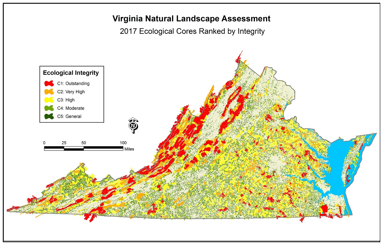
The Virginia Natural Heritage Program (VNHP) in the Department of Conservation and Recreation has developed a network of natural lands for the commonwealth of Virginia. This project, named the Virginia Natural Landscape Assessment (VaNLA), is a landscape-scale geospatial analysis for identifying, prioritizing, and linking natural lands in Virginia. Using land cover data derived from satellite imagery, the VaNLA identifies large patches of natural land with at least one hundred acres of interior cover. This interior cover, known as core area, begins one hundred meters from patch edges. Small patches with ten to ninety-nine acres of interior cover are included as habitat fragments that support landscape corridors and that may be important in localities with few large patches of natural land. For simplicity in the remainder of this document, core areas and habitat fragments will be referred to collectively as ecological cores. Although the VaNLA is predominantly an analysis of forests, ecological cores include marshes, dunes, and beaches where these covers are abundant and exceed minimum size requirements.
Ecological cores were mapped for the entire study area, which included the commonwealth of Virginia and a 20-mile buffer around the state. Over fifty attributes were assigned to the ecological cores providing information about rare species and habitats, environmental diversity, species diversity, patch characteristics, patch context, and water quality benefits. These attributes can be used by planners to select ecological cores that have the characteristics and provide the benefits of greatest interest to them. To assist in identifying highly significant ecological cores, VNHP selected nine ecological attributes and used them in a principal components analysis to develop a prioritization by ecological integrity. The following paragraph provides a synopsis of ecological integrity and describes the factors used in the prioritization.
The resulting scores were classified into five categories of ecological integrity: C1 - Outstanding; C2 - Very High; C3 - High; C4 - Moderate; and C5 - General.Maintaining vital natural landscapes is essential for basic ecosystem services such as cleaning our air and filtering our water. Natural lands also harbor thousands of species of animals and plants and contain libraries of genetic information from which we derive new foods, materials, and medicinal compounds. These parts of the landscape also provide us with recreational opportunities and open space resources. But these qualities are represented differently across the cores and habitat fragments that constitute the natural landscape. To assess their unique values, each core and habitat fragment has been assigned an Ecological Integrity Score that rates the relative contribution of that area to the ecosystem service values above. In general, larger, more biologically diverse areas are given higher scores. Scores are enhanced if the core or habitat fragment is part of a larger complex of natural lands. Scores also are increased for those cores and habitat fragments that contribute to water quality enhancement.
All ecological cores in the two highest categories (i.e. C1 and C2) were connected by landscape corridors and nodes to create a statewide network of natural lands. This was done by developing a model that represented impedances to wildlife movement through the landscape and then selecting the easiest routes between each high priority ecological core and its neighboring cohorts. These routes, known as least cost paths, were each expanded to a width of three hundred meters to create the landscape corridors. This width was chosen to maintain one hundred meters of interior cover along the entire length and one hundred meters of buffer on each side. The corridors were guided as much as possible through natural lands and lower-ranked ecological cores (i.e. C3, C4 or C5), the latter automatically becoming parts of the statewide network of natural lands as corridor nodes.
Natural landscape blocks, aggregations of one or more ecological cores and contiguous natural cover, were mapped to support the ecological cores. These blocks were created by selecting natural lands adjacent to ecological cores and establishing their boundaries at major roads and where developed areas were at least one hundred meters across. These features are analogous to hubs in other landscape assessments. Since hubs were prioritized instead of ecological cores in those assessments, the name was changed to natural landscape blocks to deemphasize them and reduce confusion. The smaller sizes of ecological cores, and the fact that they often are bounded by local roads, make them much more useful for conservation planning at the local level, thus these were the features prioritized in the this assessment.
The products of the VaNLA include GIS data, hardcopy and digital maps, and a report that summarizes the methodology and results and discusses potential uses of the GIS data. Three GIS layers, used to make the map shown in Figure 1, comprise the statewide network of natural lands: ecological cores, landscape corridors and nodes, and natural landscape blocks. Ecological cores can be viewed interactively using Natural Heritage Data Explorer or the complete suite of VaNLA products can be downloaded from links below for use with GIS software.
There are a number of potential uses for the VaNLA. It can be used to identify targets for protection activities such as conservation land purchases or easements; for guidance in comprehensive planning efforts by localities; for review of proposed projects for potential impacts to ecological cores and corridors; to guide private property owners and public and private land managers in making decisions that enhance ecological values; to inform citizens about the patterns and extent of landscape fragmentation; and to target lands for habitat restoration. Ecological cores and landscape corridors can be protected for multiple benefits including open space, trail networks, wildlife habitat, scenic view sheds, recreation, and the other benefits described in the Introduction.
The biodiversity potential, healthy wildlife populations, and ecosystem services of large ecological cores make them the highest priority targets for conservation. Planners should strive to protect ecological cores in their entirety in order to retain these benefits not only for plant and animal populations, but for human communities. Any fragmentation of ecological cores will result in an obligatory loss of benefits, with the degree of this loss being dependent upon the intensity of fragmentation. Local governments should consider revitalization of previously developed areas instead of developing our natural lands. If development of natural lands is deemed necessary, however, such development should be steered away from the largest and most ecologically significant cores remaining in that locality. If development of a significant ecological core is unavoidable, that development should be restricted to the edges or clustered towards one end, either way attempting to avoid impacts to the interior character. Current setback trends in residential developments, to maintain rural appearances, are particularly damaging to ecological cores because development is placed in the interior and the narrow strips of natural vegetation left between the development and nearby roads is predominantly edge.
As landscapes become developed, large patches of natural land become less common and the importance of landscape corridors increases. These linkages have been shown to be essential for maintaining metapopulations and conserving biodiversity in fragmented landscapes. The process of connecting ecological cores with linear strips of natural land does not ensure that those strips will function as landscape corridors. Corridors that are too narrow may consist entirely of edge and likely would not be used by sensitive species. Species attempting to use narrow corridors would be more susceptible to predation, harassment, and other edge effects mentioned previously. In order to function properly, landscape corridors must be sufficiently wide to provide their many potential benefits. It is recommended that corridors be no narrower than 300 meters, which provides interior cover along the entire length and one hundred meters of buffer on each side. Corridors should be enhanced wherever possible with the addition of corridor nodes, patches along the corridor that contain interior cover and act as stepping stones. When designed properly, landscape corridors and nodes are attractive to a wide range of species, from the rare and sensitive to the common and tolerant.
The VaNLA products have enormous potential for recreation planning. Ecological cores can be conserved as park lands for low-impact recreation (e.g. hiking, bird watching, etc.) and landscape corridors provide a vision for a network of hiking trails. Integration of humans into natural lands is essential for their understanding and appreciation of those lands, but it needs to be done in an environmentally sensitive manner where negative impacts are minimal. To maintain ecological benefits, intensive recreation should be excluded from the interior of both ecological cores and landscape corridors and directed towards the edges of these features. Furthermore, with this as a general a rule of thumb for any activities within an ecological network, these areas can benefit human and non human population simultaneously and continually.
Balmford, Andrew, Aaron Bruner, Philip Cooper, Robert Costanza, Stephen Farber, Rhys E. Green, Martin Jenkins, Paul Jefferiss, Valma Jessamy, Joah Madden, Kat Munro, Norman Myers, Shahid Naeem, Jouni Paavola, Matthew Rayment, Sergio Rosendo, Joan Roughgarden, Kate Trumper, R., and Kerry Turner. 2002. Economic reasons for conserving wild nature. Science 297: 950-953.
Beier, Paul and Reed F. Noss. 1998. Do Habitat Corridors Provide Connectivity? Conservation Biology 12:1241-1252.
Costanza, R., R. d'Arge, R. de Groot, S. Farber, M. Grasso, B. Hannon, K. Limburg, S. Naeem, R.V. O'Neill, J. Paruelo, R.G. Raskin, P. Sutton and M. van den Belt. 1997. The value of the world's ecosystem services and natural capital. Nature 387:252-259.
Damschen, Ellen I., Nick M. Haddad, and John L. Orrock. 2006. Corridors Increase Plant Species Richness at Large Scales. Science 313:1284-1286.
Harris, L. D. 1984. The Fragmented Forest . University of Chicago Press, Chicago , IL . 211pp.
Lindenmayer, B., and J. Franklin. 2002. Conserving Forest Biodiversity: A Comprehensive Multiscaled Approach. Island Press, Washington DC . 352 pp.
Tewksbury, Joshua J., Douglas J. Levey, Nick M. Haddad, Sarah Sargent, John L. Orrock, Aimee Weldon, Brent J. Danielson, Jory Brinkerhoff, Ellen I. Damschen, and Patricia Townsend. 2002. Corridors affect plants, animals, and their interactions in fragmented landscapes. Proceedings of the National Academy of Sciences 99:12923-12926.
For more information about the Virginia Natural Landscape Assessment please contact Joe Weber at Joseph.Weber@dcr.virginia.gov or 804.371.2545.


page last updated 7/2018