Department of Conservation and Recreation
Conserve. Protect. Enjoy.
Department of Conservation and Recreation


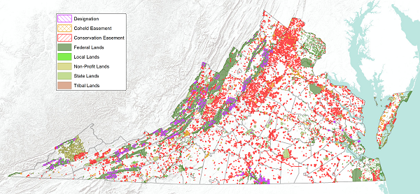
The Virginia Department of Conservation and Recreation (DCR) maintains the Conservation Lands Database, the Commonwealth’s central repository of spatial information on protected lands. These lands support natural resource management, outdoor recreation, open space preservation, and cultural heritage.
DCR began digitally mapping the boundaries for agency owned and managed State Parks and State Natural Area Preserves in 1998. In 1999, the Department of Technology Planning designated DCR as the lead agency in developing the Commonwealth's state-wide Conservation Lands Database. Since then, the database has grown to include lands protected by federal, state, and local agencies, nonprofit organizations, and private landowners. It also serves as the official source for tracking Virginia’s progress toward major past and present land conservation initiatives, such as:
The Conservation Lands Database is updated quarterly (March, June, September, December). Updated datasets are:
Downloads: Metadata and GIS spatial data are available as ZIP files (Virginia Lambert projection).
Legal Notice:GIS boundaries are not intended for legal uses and no warranty, expressed or implied, is made by the Virginia Department of Conservation and Recreation (DCR) as to the accuracy of this data. The act of distribution shall not constitute any such warranty, and no responsibility is assumed by the DCR or in the use of these data. Re-distribution of these data for profit is prohibited.
As of June 2025, Virginia has an estimated land area of 25.27 million acres. Of this, more than 4.33 million acres (17.15%) are permanently protected.
| GROUP | EASEMENTS (acres) | FEE-SIMPLE (acres) | TOTAL CONSERVED (acres) | % OF TOTAL CONSERVED |
|---|---|---|---|---|
| Federal | 14,692.77 | 2,339,668.54 | 2,354,361.31 | 54.26% |
| State | 1,005,923.27 | 452,040.12 | 1,457,963.39 | 33.60% |
| Local | 50,135.08 | 110,464.39 | 160,599.48 | 3.70% |
| Non-Profit | 258,339.27 | 106,351.06 | 364,690.33 | 8.40% |
| Tribal | 0.00 | 2,320.90 | 2,320.90 | 0.05% |
| TOTALS: | 1,329,090.38 | 3,010,845.02 | 4,339,935.40 | 100.00% |
The Office of Land Conservation provides additional resources for citizens and organizations interested in land conservation options.