Department of Conservation and Recreation
Conserve. Protect. Enjoy.
Department of Conservation and Recreation


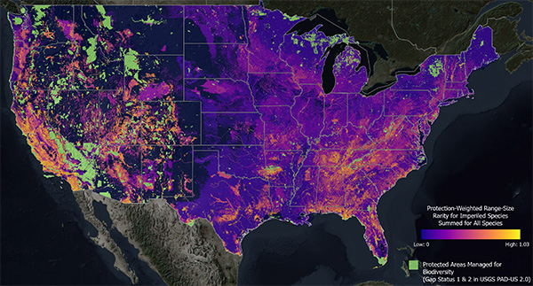
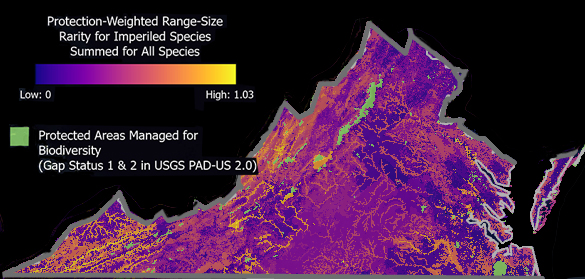
Map of Biodiversity Importance (Protection-Weighted Range Size Rarity for Imperiled Species Summed for All Species).
The Virginia Natural Heritage Program has contributed to a project led by NatureServe to develop a Map of Biodiversity Importance that offers an unprecedented, high-resolution view of where to protect the most imperiled plants and animals. In a study published in the journal Ecological Applications, this map reveals the places that matter most for sustaining the nation’s biodiversity. We spoke with Anne Chazal, chief biologist at the Virginia Natural Heritage Program and a co-author of the study.
There are a few reasons. One – we need to keep an eye on the populations we know about to determine what conservation or management actions might be required. Two – we are making decisions about land use every day. Where should a new development be sited? Where should a new bridge be constructed? Having all of the information available, including the locations of threatened and endangered species, helps us to make informed, and hopefully, wise decisions.
Previous biodiversity maps would typically show only very small areas of a single state or maybe an entire state. Very rarely do they cover an entire region like the southeastern United States. This is all the lower 48 states. The other unique attribute is that it layers all of these pieces on top of each other to show biodiversity “hotspots.” Most of the time, models focus on vertebrates or a few plants. But this one project includes an unprecedented total of 2,200 species: plants including pollinators, freshwater animals and invertebrates in addition to the more well-studied birds, mammals and amphibians.
The study found that only about 10% of the species modeled have more than 80% of their predicted habitat within protected areas. I think this indicates that we have more work to do to identify and protect important areas for these species. In Virginia, only about 10% of the land is protected, meaning it is managed with the intent of maintaining the natural state. With tools like the Map of Biodiversity Importance model and ConserveVirginia, we can begin to increase that percentage and do it wisely by identifying the most valuable areas for biodiversity.
This is one more tool in our toolbox for helping to prioritize where land protection, improved water quality, or other measures might make an impact. Keep in mind, this product is a model of what is predicted to be on the landscape. It can be used to point us to an area to investigate, but in-person observations should be the final word on how to proceed with any protection measures.
This effort can also be used to start conversations about how we prioritize our natural resources – in particular land, water and the biodiversity it supports. When Virginians learn that rivers like the Clinch, Holston and Powell are exceptional areas for fish and freshwater mussel diversity, I hope that will engender some pride that leads to their protection and stewardship.
Categories
Conservation | Native Plants | Natural Heritage
Tags
native plants