Department of Conservation and Recreation
Conserve. Protect. Enjoy.
Department of Conservation and Recreation


When rain runs off farmland and suburban lawns, it often carries harmful substances including excess nutrients and sediments into nearby waterways. This type of pollution is called nonpoint source because it does not come from a single source, or point, such as a sewage treatment plant or an industrial discharge pipe. Nutrients are substances that help plants and animals live and grow, but excessive amounts of nutrients, especially nitrogen and phosphorus, can result in algal blooms and depleted oxygen levels that can suffocate animals and plants. An estimated 50% of the nitrogen and 29% of the phosphorus entering surface waters come from farmland. Sediments are caused mainly by water running over bare land and carrying soil particles into streams, lakes, rivers, and bays, where they reduce light needed by aquatic plants, cover aquatic habitats, plants, and animals, and obstruct waterways. Comprehensive estimates of the damages from agricultural pollution are lacking, but soil erosion alone is estimated to cost water users $2 billion to $8 billion annually. Virginia's nonpoint source pollution prevention efforts focus strongly on managing nutrients and sediments because they pose the most significant threat to the health of our waterways, especially the Chesapeake Bay and its tributaries.
Once conserved permanently, water quality benefits of the lands in any of the inputs to this category will be further increased by establishing and maintaining natural vegetation in buffers. Conservation easements including deed requirements for such vegetated buffers will qualify as a ConserveVirginia success.
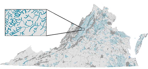
The Water Quality Improvement Opportunity Areas input identifies 788,974 acres of the highest priority lands for conservation in the interest of water quality improvement in general. It was developed via collaboration between the Department of Conservation and Recreation and the Department of Environmental Quality using estimates of nitrogen, phosphorus, and sediment loadings from agricultural sources from the Chesapeake Bay Program Phase 6 Watershed Model (CAST-2017d) and the Virginia Water Quality Assessment, and with consideration of the goals of the Chesapeake Bay Watershed Implementation Plan (WIP III). The basic approach was to identify watersheds (12-digit hydrologic units) with the highest (i.e., those in the 90th percentile) loadings of nitrogen, phosphorous, or sediment from any of the assessments used. Riparian areas along streams, creeks, and rivers in those watersheds are the focus of this ConserveVirginia input. Buffers were mapped for these waterways, where buffers ranged from 100 to 400 ft., depending on steepness of slope of adjacent lands. Generally, wider buffers were mapped for steeper slopes and for headwater streams. These buffer lands are where land conservation would be most effective to maintain and improve water quality.
The Aquatic Life Conservation Opportunity Areas input identifies 340,938 acres of the highest priority lands for conservation in the interest of protecting waters of high integrity. In order to identify waters with outstanding ecological conditions for consideration as high-priority conservation areas, DEQ conducted a thorough review of its biological monitoring data to identify least disturbed sites throughout the Commonwealth. Associated watersheds and riparian buffers were used to identify land areas where conservation efforts may be most beneficial to protect high quality waters. DEQ identified 173 unique, high quality watersheds with 845 km2 of riparian area. These land areas and freshwater systems support living aquatic communities that indicate least-disturbed water quality and habitat conditions. The overall water quality ratings based on these communities are among the top 5% expected in Virginia’s streams and rivers, as indicated by the biomonitoring indices used by DEQ for conducting water quality assessments.
The Healthy Waters Conservation Opportunity Areas input identifies 186,653 acres of the highest priority lands for conservation in the interest of protecting confirmed healthy waters. Healthy waters are streams that are ranked as “outstanding” or “healthy” based on fish and macroinvertebrate communities, and instream and riparian habitat data, through a stream ecological integrity assessment known as Interactive Stream Assessment Resource (INSTAR). This input to ConserveVirginia was developed with funding from a Chesapeake Bay Implementation Grant in collaboration between the Department of Conservation and Recreation and the Center for Environmental Studies at Virginia Commonwealth University using estimates of nitrogen, phosphorus, and sediment loadings from agricultural sources from the 2020 NPS Pollution Assessment and Prioritization (DCR Soil and Water Conservation, 2020). The basic approach was to rank 10-km truncated drainages for each pollutant and retain those which had a relative yield in the top 50th-percentile for any of the three pollutants. For those drainages that remained, riparian buffers were delineated using overland flow length while accounting for soil sensitivity.
The Restoration Candidate Best Management Practices Opportunity Areas input identifies 156,089 acres of the highest priority lands for targeting agricultural best management practices (BMP) in the interest improving water quality for restoration candidate waters. This input targets waters that don’t qualify as healthy based on fish and macroinvertebrate communities, and instream and riparian habitat data, from the stream ecological integrity assessment known as Interactive Stream Assessment Resource (INSTAR), but which may become healthy with restoration. This input to ConserveVirginia was developed with funding from a Chesapeake Bay Implementation Grant in collaboration between the Department of Conservation and Recreation and the Center for Environmental Studies at Virginia Commonwealth University. The first step in this analysis involved removing form consideration those 10-km truncated drainages that had greater than 5% impervious cover because BMP and land conservation would not be effective in improving the quality of waters degraded by residential and industrial development. The basic method was to delineated riparian buffers using overland flow length for the retained drainages and then extract and categorize non-impervious land covers within the riparian buffers. The classification allows for targeting non-agricultural covers for conservation and agricultural land covers for BMP and conservation. The data resource areas in the Water Quality Improvement category represent a total of 1,334,576 acres.
| Water Quality Improvement | YES/NO – Includes opportunity area for reducing non-point source pollution to improve water quality. |
| Aquatic Life Conservation Opportunity Areas | YES/NO – Includes opportunity area for conserving waters of high ecological integrity. |
| Healthy Waters Conservation Opportunity Areas | YES/NO – Includes opportunity area for conserving confirmed Health Waters. |
| Restoration Candidate Best Management Practices Opportunity Areas | YES/NO – Includes opportunity area for improving water quality through agricultural best management practices. |
| Map Date | Map creation date |
| Deed Requirement | Required protections to meet ConserveVirginia Standards |
Help Documents
How to use the Natural Heritage Data Explorer for interactive versions of all ConserveVirginia maps.
View a Demonstration Video
How to use interactive ConserveVirginia maps on the Virginia Natural Heritage Data Explorer.